
Payl:FumaroleButte USGS.jpg
Walay mas taas nga resolusyon.
FumaroleButte_USGS.jpg (400 × 271 pixels, size sa payl: 12 KB, MIME type: image/jpeg)
Mubong sugid:
| Deskripsyon |
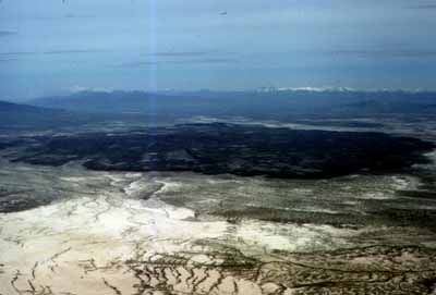
English: USGS description: Fumarole Butte is a basaltic flow erupted during Pleistocene time. It is a basaltic example of the bimodal basalt-rhyolite volcanism that accompanied basin-range faulting during Miocene to present time. The butte is located about 20 miles southeast of Spor Mountain and can be accessed by road along the east side, from the paved highway connecting Spor Mountain to route 50. A detailed geologic map of the butte and surrounding Lake Bonneville deposits was made by Galyardt and Rush (1981). This is an aerial view of Fumarole Butte looking northeast; the snow-capped mountains on the skyline are the Oquirrh Range. |
| Petsa | |
| Gigikanan | USGS report ofr-98-0524 [1] |
| Tagsulat | USGS |
Pagtugot
This image is in the public domain in the United States because it only contains materials that originally came from the United States Geological Survey, an agency of the United States Department of the Interior. For more information, see the official USGS copyright policy.
|
Kaagi sa payl
I-klik ang petsa/oras aron makit-an ang hulagway sa payl niadtong panahona.
| Petsa/Takna | Thumbnail | Mga dimensyon | Tiggamit | Komento | |
|---|---|---|---|---|---|
| kasamtangan | 15:53, 13 Nobiyembre 2010 | | 400 × 271 (12 KB) | Mikenorton | {{Information |Description={{en|1=Aerial view of Fumarole Butte, with the snow-capped Oquirrh Range in the background}} |Source=USGS report ofr-98-0524 [http://pubs.usgs.gov/of/1998/ofr-98-0524/HOME.HTM] |Author=USGS |Date=1978 |Permission= |other_versio |
Mga paggamit sa payl
Ang mosunod nga mga panid misumpay niining payl:
Global nga paggamit sa payl
Kining ubang wiki naggamit ning maong payl:
- Paggamit sa en.wikipedia.org
- Paggamit sa eu.wikipedia.org
- Paggamit sa www.wikidata.org