Payl:Gibraltar map-en.svg
Page contents not supported in other languages.
Gikan sa Wikipedia, ang gawasnong ensiklopedya

Tibuok resolusyon(SVG nga payl, nominally 2,020 × 3,140 pixels, size sa payl: 289 KB)

Kining maong payl gikan sa Wikimedia Commons ug mahimong gigamit sa ubang proyekto. Ang deskripsyon niini didto gipakita sa ubos.

Image of the year
Image of the year
Featured image

Wikimedia Commons

This file was a candidate in Picture of the Year 2007.
This is a featured picture on Wikimedia Commons (Featured pictures) and is considered one of the finest images. See its nomination here.

If you have an image of similar quality that can be published under a suitable copyright license, be sure to upload it, tag it, and nominate it.

Mubong sugid:

Camera location36° 08′ 00″ N, 5° 21′ 00″ W Kartographer map based on OpenStreetMap.View this and other nearby images on: OpenStreetMapinfo
Deskripsyon
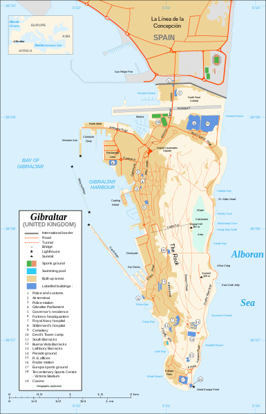
Čeština: Mapa ostrova Gibraltar v angličtině.
English: Map in English of Gibraltar.
Français : * Sujet : Carte en anglais de Gibraltar ;
  • Sources : Création personnelle ;
  • Carte créée à partir de captures d'écran d'images satellite de Google Earth d'un point de vue placé à 1,18 km d'altitude (imagerie disponible de novembre 2007) ;
  • Références complémentaires :
  • Échelle approximative : 1:40 000 (précision : environ 10 m) ;
  • Note : Largeur du tracé des routes proportionnelle à la réalité ;
  • Auteur : Eric Gaba (fr:Sting) ;
  • Date : Novembre 2007.
Português: Mapa (em Inglês) de Gibraltar.
Petsa
Gigikanan Own work ;
Map created using screenshots of Google Earth satellite imagery from a point of view located at 1.18 km of altitude (available imagery of November 2007) ;
Other references :
* CIA map ;
* Gibnet map ;
* U.K. MoD map
Locator map : Image:Blank_map_of_South_Europe_and_North_Africa.svg (modified) created by Historicair ;
Approximate scale : 1:40,000 (accuracy : about 10 m)
Note : The roads width is proportional to reality
Tagsulat Eric Gaba (Sting)
Pagtugot
(Paggamit pag-usab niini nga file)
Attribution and Share-Alike required
Other versions

[usba]

Disputed isthmus and land
SVG genesis
InfoField
 
The SVG code is valid.
 
This map was created with Inkscape…important.
 
 This map uses embedded text that can be easily translated using a text editor.

Pagtugot

I, the copyright holder of this work, hereby publish it under the following licenses:
GNU head Gitugot ang pagkopya, pag-apud-apod o/ug pag-usab ning maong dokumento ubos sa mga termino sa GNU Free Documentation License, Version 1.2 o mas bag-ong bersiyon nga gimantala sa Free Software Foundation; nga walay Invariant Sections, walay Front-Cover Texts, ug walay Back-Cover Texts. Ang kopya sa lisensiya gilakip sa bahin nga giulohang GNU Free Documentation License.
w:en:Creative Commons
atribusyon share parehas
This file is licensed under the Creative Commons Attribution-Share Alike 4.0 International, 3.0 Unported, 2.5 Generic, 2.0 Generic and 1.0 Generic license.
Libre ka:
  • sa pagsabwag – sa pagkopya, pag-apod-apod ug pagsabwag sa hinimo
  • sa pag-remix – sa pag-adap sa binuhat
Ubos sa mosunod nga mga kondisyon:
  • atribusyon – Kinahanglan nimo nga hatagan ang angay nga kredito, maghatag usa ka link sa lisensya, ug ipakita kung adunay mga pagbag-o. Mahimo nimo kini buhaton sa bisan unsang makatarunganon nga paagi, apan dili sa bisan unsang paagi nga nagsugyot nga gi-endorso ka sa licensor o ang imong paggamit.
  • share parehas – Kung imong gi-remix, gibag-o, o gibase sa materyal, kinahanglan nimo nga iapod-apod ang imong mga kontribusyon sa ilawom sa parehas o katugma nga lisensya sama sa orihinal.
You may select the license of your choice.

Captions

Add a one-line explanation of what this file represents

Items portrayed in this file

depicts English

copyrighted English

Nobiyembre 2007

36°7'59.999"N, 5°21'0.000"W

media type English

image/svg+xml

Kaagi sa payl

I-klik ang petsa/oras aron makit-an ang hulagway sa payl niadtong panahona.

Petsa/TaknaThumbnailMga dimensyonTiggamitKomento
kasamtangan20:10, 21 Pebrero 2020Thumbnail sa bersyon sa 20:10, 21 Pebrero 20202,020 × 3,140 (289 KB)JoKalliauermalformed svg (compare firefox/chrome rendering with librsvg-rendering) actually firefox/chrome were correct, also it looks wrong
06:01, 29 Hunyo 2017Thumbnail sa bersyon sa 06:01, 29 Hunyo 20172,020 × 3,140 (538 KB)Wereldburger758Removal error in file. Valid SVG now.
21:52, 27 Agosto 2008Thumbnail sa bersyon sa 21:52, 27 Agosto 20082,020 × 3,140 (569 KB)RedCoatRemove "claimed by Spain", completely gratuitous for a map
11:28, 11 Disyembre 2007Thumbnail sa bersyon sa 11:28, 11 Disyembre 20072,020 × 3,140 (570 KB)StingNotification of the Spanish claims
14:40, 27 Nobiyembre 2007Thumbnail sa bersyon sa 14:40, 27 Nobiyembre 20072,020 × 3,140 (569 KB)StingAdditional names ; up-to-date corrections
21:35, 26 Nobiyembre 2007Thumbnail sa bersyon sa 21:35, 26 Nobiyembre 20072,020 × 3,140 (561 KB)RedCoatHouse of Assembly → Gibraltar Parliament
19:51, 26 Nobiyembre 2007Thumbnail sa bersyon sa 19:51, 26 Nobiyembre 20072,020 × 3,140 (561 KB)Sting+ info
14:12, 26 Nobiyembre 2007Thumbnail sa bersyon sa 14:12, 26 Nobiyembre 20072,020 × 3,140 (561 KB)Sting+ info
13:21, 26 Nobiyembre 2007Thumbnail sa bersyon sa 13:21, 26 Nobiyembre 20072,020 × 3,140 (561 KB)Sting{{Information |Description=Map in English of Gibraltar |Source=Own work ;<br/>Map created using screenshots of Google Earth satellite imagery from a point of view located at 1.18 km of altitude (available image

There are no pages that use this file.

Global nga paggamit sa payl

Kining ubang wiki naggamit ning maong payl:

Metadata