
Payl:Gushikawa Island gsi-20081025.jpg

Gidak-on ning maong paunang tan-aw: 660 x 600 ka mga piksel. Uban pang mga resoluyon: 264 x 240 ka mga piksel | 528 x 480 ka mga piksel | 845 x 768 ka mga piksel | 1,126 x 1,024 ka mga piksel | 2,200 x 2,000 ka mga piksel.
Tibuok resolusyon (2,200 × 2,000 pixels, size sa payl: 757 KB, MIME type: image/jpeg)
Mubong sugid:
| Deskripsyon |
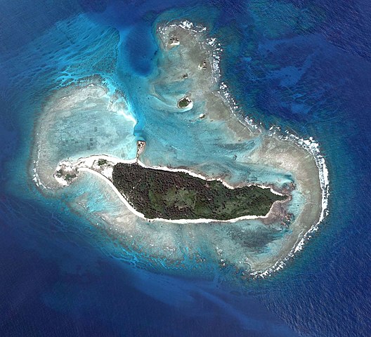
English: Gushikawa Island, Izena, Okinawa, Japan.
日本語: 具志川島。国土交通省の地図・空中写真閲覧サービスを元に作成。4枚の航空写真を使用。
|
| Petsa | |
| Gigikanan | COK20081X-C2-1, C2-2, C2-3, C2-4 |
| Tagsulat |
English: Geospatial Information Authority of Japan
日本語: 国土地理院 |
| Camera location | | View this and other nearby images on: OpenStreetMap |
|---|
| This is a retouched picture, which means that it has been digitally altered from its original version. Modifications: Combined 4 aerial photos, rotated upward to north direction, and cropped. Modifications made by Kugel~commonswiki.
|
Pagtugot

|
The copyright holder of this file, Ministry of Land, Infrastructure, Transport and Tourism, allows anyone to use it for any purpose, provided that the copyright holder is properly attributed. Redistribution, derivative work, commercial use, and all other use is permitted. |
Attribution:
National Land Image Information (Color Aerial Photographs), created by Ministry of Land, Infrastructure, Transport and Tourism, distributed by Geospatial Information Authority of Japan
|

Kaagi sa payl
I-klik ang petsa/oras aron makit-an ang hulagway sa payl niadtong panahona.
| Petsa/Takna | Thumbnail | Mga dimensyon | Tiggamit | Komento | |
|---|---|---|---|---|---|
| kasamtangan | 11:03, 30 Septiyembre 2016 | | 2,200 × 2,000 (757 KB) | Kugel~commonswiki | {{Information |description={{en|Gushikawa Island, Izena, Okinawa, Japan.}} {{ja|具志川島 国土交通省の地図・空中写真閲覧サービスを元に作成。4枚の航空写真を使用。 * 整理番号 : COK20081X * 撮影年月日 : 2008... |
Mga paggamit sa payl
Ang mosunod nga mga panid misumpay niining payl:
Global nga paggamit sa payl
Kining ubang wiki naggamit ning maong payl:
- Paggamit sa ja.wikipedia.org
- Paggamit sa www.wikidata.org
- Paggamit sa zh-min-nan.wikipedia.org
- Paggamit sa zh.wikipedia.org