
Payl:Jylland overview map2.PNG

Gidak-on ning maong paunang tan-aw: 332 x 600 ka mga piksel. Uban pang mga resoluyon: 133 x 240 ka mga piksel | 266 x 480 ka mga piksel | 964 x 1,741 ka mga piksel.
Tibuok resolusyon (964 × 1,741 pixels, size sa payl: 171 KB, MIME type: image/png)

|
This historical map image could be re-created using vector graphics as an SVG file. This has several advantages; see Commons:Media for cleanup for more information. If an SVG form of this image is available, please upload it and afterwards replace this template with
{{vector version available|new image name}}.
It is recommended to name the SVG file “Jylland overview map2.svg”—then the template Vector version available (or Vva) does not need the new image name parameter. |
Mubong sugid:
| Deskripsyon |
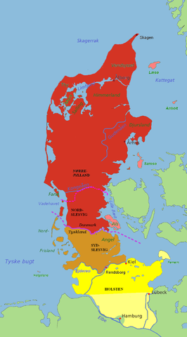
Jutland and the Jutland Peninsula Red: Commonly defined as Jutland today, including the area north of the Limfjord and minor islands Pink: The islands of Læsø, Anholt, Samsø and Als are usually attributed to Jutland as well Brown: South Slesvig/Schleswig in the German state of Schleswig-Holstein, historically a part of Jutland Yellow: Holstein, situated on the Jutland Peninsula, but not in Jutland itself. The river Kongeå is the historical border between Northern and Southern Jutland (Slesvig). The river Eider is the historical southern border of Jutland (and formerly Denmark), and between Slesvig and Holstein. The city of Rendsburg and the island of Helgoland are sometimes regarded as Slesvig, sometimes not. The Jutland Peninsula as a geographic term has no fixed southern border, but at its furthest it would stretch to the river Elbe. Hamburg, however, is not a part of Holstein, and Lübeck was not a part of Holstein until the 20th century. The Jutland Peninsula may also be called the Cimbrian Peninsula, Jutland-Holstein or Jutland-Schleswig-Holstein. |
| Petsa | |
| Gigikanan | self-made / edited from original map by Astrokey44 (GFDL). |
| Tagsulat | Casper |
Pagtugot
I, Casper, the copyright holder of this work, hereby publishes it under the following licenses:

|
Gitugot ang pagkopya, pag-apud-apod o/ug pag-usab ning maong dokumento ubos sa mga termino sa GNU Free Documentation License, Version 1.2 o mas bag-ong bersiyon nga gimantala sa Free Software Foundation; nga walay Invariant Sections, walay Front-Cover Texts, ug walay Back-Cover Texts. Ang kopya sa lisensiya gilakip sa bahin nga giulohang GNU Free Documentation License. |
| This file is licensed under the Creative Commons Attribution-Share Alike 3.0 Unported license. | ||
| Attribution: I, Casper | ||
| ||
| This licensing tag was added to this file as part of the GFDL licensing update. |
This file is licensed under the Creative Commons Attribution-Share Alike 2.5 Generic, 2.0 Generic and 1.0 Generic license.
Attribution: I, Casper
- Libre ka:
- sa pagsabwag – sa pagkopya, pag-apod-apod ug pagsabwag sa hinimo
- sa pag-remix – sa pag-adap sa binuhat
- Ubos sa mosunod nga mga kondisyon:
- atribusyon – Kinahanglan nimo nga hatagan ang angay nga kredito, maghatag usa ka link sa lisensya, ug ipakita kung adunay mga pagbag-o. Mahimo nimo kini buhaton sa bisan unsang makatarunganon nga paagi, apan dili sa bisan unsang paagi nga nagsugyot nga gi-endorso ka sa licensor o ang imong paggamit.
- share parehas – Kung imong gi-remix, gibag-o, o gibase sa materyal, kinahanglan nimo nga iapod-apod ang imong mga kontribusyon sa ilawom sa parehas o katugma nga lisensya sama sa orihinal.
You may select the license of your choice.
Kaagi sa payl
I-klik ang petsa/oras aron makit-an ang hulagway sa payl niadtong panahona.
| Petsa/Takna | Thumbnail | Mga dimensyon | Tiggamit | Komento | |
|---|---|---|---|---|---|
| kasamtangan | 03:03, 10 Hulyo 2007 | | 964 × 1,741 (171 KB) | Casper~commonswiki | == Summary == {{Information |Description='''Jutland and the Jutland Peninsula'''<br><br>'''Red:''' Commonly defined as Jutland today, including the area north of the Limfjord and minor islands<br>'''Pink:''' The islands of Læsø, Anholt, Samsø and Als a |
Mga paggamit sa payl
Ang mosunod nga mga panid misumpay niining payl:
Global nga paggamit sa payl
Kining ubang wiki naggamit ning maong payl:
- Paggamit sa be.wikipedia.org
- Paggamit sa ca.wikipedia.org
- Paggamit sa da.wikipedia.org
- Paggamit sa en.wikipedia.org
- Paggamit sa es.wikipedia.org
- Paggamit sa fa.wikipedia.org
- Paggamit sa fr.wikipedia.org
- Paggamit sa it.wikipedia.org
- Paggamit sa ko.wikipedia.org
- Paggamit sa nn.wikipedia.org
- Paggamit sa no.wikipedia.org
- Paggamit sa pt.wikipedia.org
- Paggamit sa ru.wikipedia.org
- Paggamit sa sv.wikipedia.org
- Paggamit sa vi.wikipedia.org
- Paggamit sa wa.wikipedia.org
- Paggamit sa www.wikidata.org