
Payl:Kybun-tower-roggwil.jpg

Gidak-on ning maong paunang tan-aw: 800 x 532 ka mga piksel. Uban pang mga resoluyon: 320 x 213 ka mga piksel | 640 x 426 ka mga piksel | 1,024 x 681 ka mga piksel | 1,280 x 851 ka mga piksel | 3,008 x 2,000 ka mga piksel.
Tibuok resolusyon (3,008 × 2,000 pixels, size sa payl: 1.56 MB, MIME type: image/jpeg)
Mubong sugid:
| Deskripsyon |
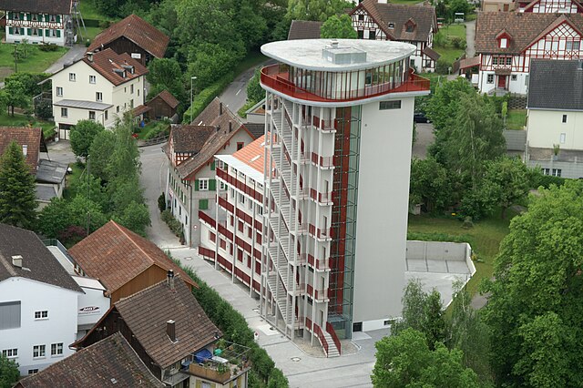
English: kybun Tower in Roggwil(TG), Switzerland. The 30 meter high tower was a mill before the modification took place in 2006/2007. As of today it's the headquater of the kybun AG. The picture was taken out of a helicopter. In the background you can see typical half-timbered houses.
Deutsch: kybun Tower in Roggwil(TG), Schweiz. Der 30 Meter hohe Turm war früher eine Mühle und wurde zwischen 2006/2007 umgebaut. Heute ist es der Firmensitz der kybun AG. Aufgenommen aus einem Hubschrauber. Im Hintergrund sind typische Fachwerkhäuser (Riegelhäuser) zu sehen. |
| Petsa | |
| Gigikanan | Medienarchiv kybun AG, Kaugalingong trabaho |
| Tagsulat | kybun AG, Patrick Eich |
| Pagtugot (Paggamit pag-usab niini nga file) |
| Camera location | | View this and other nearby images on: OpenStreetMap |
|---|
Pagtugot
I, the copyright holder of this work, hereby publish it under the following license:
This file is licensed under the Creative Commons Attribution-Share Alike 3.0 Unported license.
- Libre ka:
- sa pagsabwag – sa pagkopya, pag-apod-apod ug pagsabwag sa hinimo
- sa pag-remix – sa pag-adap sa binuhat
- Ubos sa mosunod nga mga kondisyon:
- atribusyon – Kinahanglan nimo nga hatagan ang angay nga kredito, maghatag usa ka link sa lisensya, ug ipakita kung adunay mga pagbag-o. Mahimo nimo kini buhaton sa bisan unsang makatarunganon nga paagi, apan dili sa bisan unsang paagi nga nagsugyot nga gi-endorso ka sa licensor o ang imong paggamit.
- share parehas – Kung imong gi-remix, gibag-o, o gibase sa materyal, kinahanglan nimo nga iapod-apod ang imong mga kontribusyon sa ilawom sa parehas o katugma nga lisensya sama sa orihinal.
Kaagi sa payl
I-klik ang petsa/oras aron makit-an ang hulagway sa payl niadtong panahona.
| Petsa/Takna | Thumbnail | Mga dimensyon | Tiggamit | Komento | |
|---|---|---|---|---|---|
| kasamtangan | 07:55, 18 Pebrero 2011 | | 3,008 × 2,000 (1.56 MB) | KMFoundation | {{Information |Description ={{en|1=kybun Tower in Roggwil(TG), Switzerland. The 30 meter high tower was a mill before the modification took place in 2006/2007. As of today it's the headquater of the kybun AG. The picture was taken out of a helicopter. |
Mga paggamit sa payl
Ang mosunod nga mga panid misumpay niining payl:
Global nga paggamit sa payl
Kining ubang wiki naggamit ning maong payl:
- Paggamit sa als.wikipedia.org
- Paggamit sa ar.wikipedia.org
- Paggamit sa ca.wikipedia.org
- Paggamit sa de.wikipedia.org
- Paggamit sa en.wikipedia.org
- Paggamit sa es.wikipedia.org
- Paggamit sa eu.wikipedia.org
- Paggamit sa it.wikipedia.org
- Paggamit sa lmo.wikipedia.org
- Paggamit sa nn.wikipedia.org
- Paggamit sa pl.wikipedia.org
- Paggamit sa ru.wikipedia.org
- Paggamit sa simple.wikipedia.org
- Paggamit sa sv.wikipedia.org
- Paggamit sa uk.wikipedia.org
- Paggamit sa uz.wikipedia.org
- Paggamit sa vec.wikipedia.org
- Paggamit sa www.wikidata.org
- Paggamit sa zh.wikipedia.org