
Payl:La Pérouse memorial on Vanikoro.jpg
Gidak-on ning maong paunang tan-aw: 513 x 599 ka mga piksel. Uban pang mga resoluyon: 205 x 240 ka mga piksel | 411 x 480 ka mga piksel | 709 x 828 ka mga piksel.
Tibuok resolusyon (709 × 828 pixels, size sa payl: 455 KB, MIME type: image/jpeg)
Mubong sugid:
| Deskripsyon |
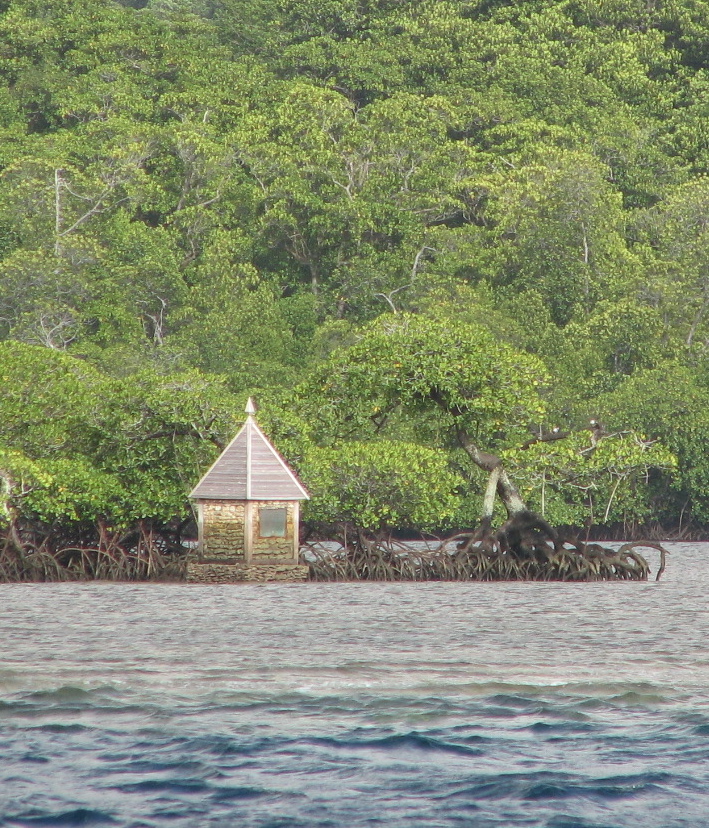
English: Memorial to French explorer La_Pérouse in Mangadai Bay, Vanikoro Island, Temotu Province, Solomon Islands. Memorial is at 11 39.02 S 166 55.52 E. This is actually on the opposite side of the island to where the wrecks of Lapérouse's ships were located. |
| Petsa | |
| Gigikanan | Self-photographed |
| Tagsulat | My own photo |
| Camera location | | View this and other nearby images on: OpenStreetMap |
|---|
The monument was erected by Dumont d'Urville in 1828 - engraving of it in "Voyage de la corvette l'Astrolabe : exécuté par ordre du roi, pendant les années 1826, 1827, 1828, 1829, sous le commandement de M. J. Dumont D'Urville, capitaine de vaisseau." shown here: http://www.sl.nsw.gov.au/discover_collections/society_art/french/perouse/index.html
Pagtugot
I, the copyright holder of this work, hereby publish it under the following licenses:

|
Gitugot ang pagkopya, pag-apud-apod o/ug pag-usab ning maong dokumento ubos sa mga termino sa GNU Free Documentation License, Version 1.2 o mas bag-ong bersiyon nga gimantala sa Free Software Foundation; nga walay Invariant Sections, walay Front-Cover Texts, ug walay Back-Cover Texts. Ang kopya sa lisensiya gilakip sa bahin nga giulohang GNU Free Documentation License. |
This file is licensed under the Creative Commons Attribution-Share Alike 4.0 International, 3.0 Unported, 2.5 Generic, 2.0 Generic and 1.0 Generic license.
- Libre ka:
- sa pagsabwag – sa pagkopya, pag-apod-apod ug pagsabwag sa hinimo
- sa pag-remix – sa pag-adap sa binuhat
- Ubos sa mosunod nga mga kondisyon:
- atribusyon – Kinahanglan nimo nga hatagan ang angay nga kredito, maghatag usa ka link sa lisensya, ug ipakita kung adunay mga pagbag-o. Mahimo nimo kini buhaton sa bisan unsang makatarunganon nga paagi, apan dili sa bisan unsang paagi nga nagsugyot nga gi-endorso ka sa licensor o ang imong paggamit.
- share parehas – Kung imong gi-remix, gibag-o, o gibase sa materyal, kinahanglan nimo nga iapod-apod ang imong mga kontribusyon sa ilawom sa parehas o katugma nga lisensya sama sa orihinal.
You may select the license of your choice.
Kaagi sa payl
I-klik ang petsa/oras aron makit-an ang hulagway sa payl niadtong panahona.
| Petsa/Takna | Thumbnail | Mga dimensyon | Tiggamit | Komento | |
|---|---|---|---|---|---|
| kasamtangan | 09:42, 22 Marso 2009 | | 709 × 828 (455 KB) | Pohopetch | {{Information |Description={{en|1=Memorial to French explorer La_Pérouse in Mangadai Bay, Vanikoro Island, Temotu Province, Solomon Islands. Erected in 2006 or 2007.}} |Source=My own photo |Author=My own photo |Date=2008-09-10 |Permission= |other_version |
Mga paggamit sa payl
Ang mosunod nga mga panid misumpay niining payl:
Global nga paggamit sa payl
Kining ubang wiki naggamit ning maong payl:
- Paggamit sa az.wikipedia.org
- Paggamit sa bg.wikipedia.org
- Paggamit sa br.wikipedia.org
- Paggamit sa de.wikipedia.org
- Paggamit sa el.wikipedia.org
- Paggamit sa en.wikipedia.org
- Paggamit sa eo.wikipedia.org
- Paggamit sa fr.wikipedia.org
- Paggamit sa gl.wikipedia.org
- Paggamit sa ja.wikipedia.org
- Paggamit sa nl.wikipedia.org
- Paggamit sa oc.wikipedia.org
- Paggamit sa vi.wikipedia.org