
Payl:Location Of Prionezhsky District (Karelia).svg

Size of this PNG preview of this SVG file: 400 x 600 ka mga piksel. Uban pang mga resoluyon: 160 x 240 ka mga piksel | 320 x 480 ka mga piksel | 512 x 768 ka mga piksel | 683 x 1,024 ka mga piksel | 1,366 x 2,048 ka mga piksel | 1,309 x 1,962 ka mga piksel.
Tibuok resolusyon (SVG nga payl, nominally 1,309 × 1,962 pixels, size sa payl: 182 KB)
.svg)
Mubong sugid:
| Deskripsyon |
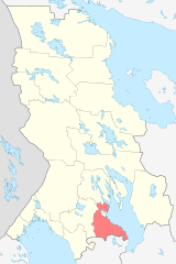
English: Image to indicate Karelia districts. Subject as indicated by filename. |
| Petsa | |
| Gigikanan |
Kaugalingong trabaho This W3C-unspecified vector image was created with Inkscape . |
| Tagsulat | Виктор В |
Pagtugot
| I, the copyright holder of this work, release this work into the public domain. This applies worldwide. In some countries this may not be legally possible; if so: I grant anyone the right to use this work for any purpose, without any conditions, unless such conditions are required by law. |
Kaagi sa payl
I-klik ang petsa/oras aron makit-an ang hulagway sa payl niadtong panahona.
| Petsa/Takna | Thumbnail | Mga dimensyon | Tiggamit | Komento | |
|---|---|---|---|---|---|
| kasamtangan | 16:52, 21 Marso 2010 | | 1,309 × 1,962 (182 KB) | Виктор В | == {{int:filedesc}} == {{Information |Description={{en|1=Image to indicate Karelia districts. Subject as indicated by filename.}} |Source={{own}} {{Inkscape}} Схема территориального планирования Республики Кар |
Mga paggamit sa payl
Ang mosunod nga mga panid misumpay niining payl:
Global nga paggamit sa payl
Kining ubang wiki naggamit ning maong payl:
- Paggamit sa ce.wikipedia.org
- Paggamit sa es.wikipedia.org
- Paggamit sa fi.wikipedia.org
- Paggamit sa frr.wikipedia.org
- Paggamit sa fr.wikipedia.org
- Paggamit sa hu.wikipedia.org
- Paggamit sa hy.wikipedia.org
- Paggamit sa it.wikipedia.org
- Paggamit sa lt.wikipedia.org
- Paggamit sa lv.wikipedia.org
- Paggamit sa nl.wikipedia.org
- Paggamit sa olo.wikipedia.org
- Paggamit sa pl.wikipedia.org
- Paggamit sa ru.wikipedia.org
- Paggamit sa sco.wikipedia.org
- Paggamit sa vep.wikipedia.org
- Paggamit sa vi.wikipedia.org
- Paggamit sa www.wikidata.org
- Paggamit sa zh-min-nan.wikipedia.org
.svg)