
Payl:Maranhao MesoMicroMunicip.svg

Size of this PNG preview of this SVG file: 459 x 599 ka mga piksel. Uban pang mga resoluyon: 184 x 240 ka mga piksel | 367 x 480 ka mga piksel | 588 x 768 ka mga piksel | 784 x 1,024 ka mga piksel | 1,568 x 2,048 ka mga piksel | 758 x 990 ka mga piksel.
Tibuok resolusyon (SVG nga payl, nominally 758 × 990 pixels, size sa payl: 679 KB)

|
Standardization of derivative maps
Feel free to create derivations of this work, but if you want to illustrate a Wikipedia article with derivative works of this or similar maps of Brazil, please strictly follow the visual standard, nomenclature and classification already in use. All maps of Brazilian subdivisions are being adaptated or created in this way. We do not want to inhibit creativity but the pattern adopted here was presented and accepted by the Lusophone community and should be followed whenever possible. |
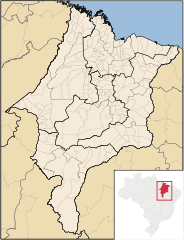
| Deskripsyon | Map of Maranhão state | ||||||||
| Petsa | |||||||||
| Gigikanan | Kaugalingong trabaho | ||||||||
| Tagsulat | Raphael Lorenzeto de Abreu | ||||||||
| Pagtugot (Paggamit pag-usab niini nga file) |
I, the copyright holder of this work, hereby publish it under the following licenses:
This file is licensed under the Creative Commons Attribution 2.5 Generic license.
You may select the license of your choice. |
||||||||
| Other versions | Derivative works of this file: Brazil Maranhao location map.svg |

| Annotations | This image is annotated: View the annotations at Commons |
Kaagi sa payl
I-klik ang petsa/oras aron makit-an ang hulagway sa payl niadtong panahona.
| Petsa/Takna | Thumbnail | Mga dimensyon | Tiggamit | Komento | |
|---|---|---|---|---|---|
| kasamtangan | 04:04, 8 Septiyembre 2006 | | 758 × 990 (679 KB) | Raphael.lorenzeto | |
| 08:58, 29 Abril 2006 |  | 581 × 687 (669 KB) | Raphael.lorenzeto | {{Information| |Description=Map of Maranhão state |Source=own work |Date=April, 29 2006 |Author=Raphael Lorenzeto de Abreu |Permission={{self2|GFDL|cc-by-2.5}} |other_versions= }} Category:Maps of Maranhão |
Mga paggamit sa payl
There are no pages that use this file.
Global nga paggamit sa payl
Kining ubang wiki naggamit ning maong payl:
- Paggamit sa eo.wikipedia.org
- Paggamit sa es.wikipedia.org
- Paggamit sa fr.wikipedia.org
- Paggamit sa pt.wikipedia.org
- Paggamit sa pt.wiktionary.org
- Paggamit sa ro.wikipedia.org
- Paggamit sa sr.wikipedia.org
- Paggamit sa zh.wikipedia.org