
Payl:Mount Shuksan 8760.JPG

Gidak-on ning maong paunang tan-aw: 800 x 533 ka mga piksel. Uban pang mga resoluyon: 320 x 213 ka mga piksel | 640 x 427 ka mga piksel | 1,024 x 683 ka mga piksel | 1,280 x 853 ka mga piksel | 2,560 x 1,707 ka mga piksel | 4,272 x 2,848 ka mga piksel.
Tibuok resolusyon (4,272 × 2,848 pixels, size sa payl: 4.56 MB, MIME type: image/jpeg)
Mubong sugid:
| Deskripsyon |
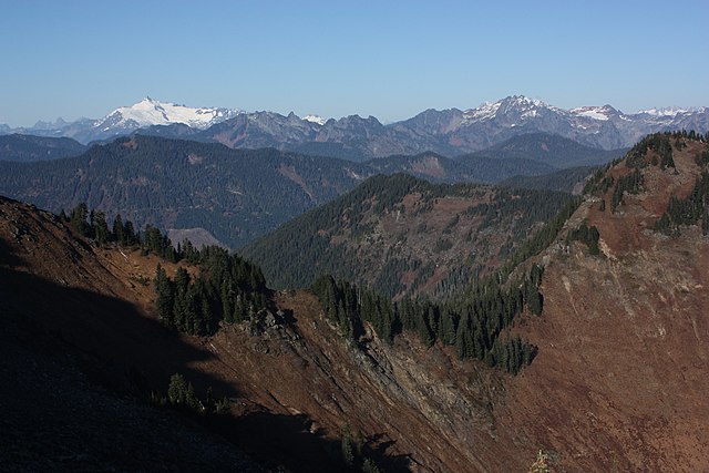
English: Mount Shuksan (left skyline) with Sulphide Glacer (left) and Crystal Glacier (right); Anderson Butte (in front of Crystal Glacier); Mount Watson (left center skyline middle distance); Canadian Border Peak and American Border Peak (skyline left of Shuksan); Bacon Peak (7061 feet, 2152 m, right skyline) with Mount Blum (7680 feet, 2341 m, left and behind)
|
| Petsa | 28 Oktubre 2013, 21:56:57 +00:00 |
| Gigikanan | Kaugalingong trabaho |
| Tagsulat | Walter Siegmund (talk) |
| Camera location | | View this and other nearby images on: OpenStreetMap |
|---|
| Camera Model | Canon EOS DIGITAL REBEL XSi |
|---|---|
| Shutter speed | 1/1000 |
| Aperture | f/11.0 |
| Film speed (ISO) | 400 |
| Focal length | 32.0 |
| Filter(s) | Hoya Circular Polarizer, HOCPMC67 |

|
This image is the work of Walter Siegmund
|
Pagtugot
I, the copyright holder of this work, hereby publish it under the following license:
This file is licensed under the Creative Commons Attribution-Share Alike 3.0 Unported license.
- Libre ka:
- sa pagsabwag – sa pagkopya, pag-apod-apod ug pagsabwag sa hinimo
- sa pag-remix – sa pag-adap sa binuhat
- Ubos sa mosunod nga mga kondisyon:
- atribusyon – Kinahanglan nimo nga hatagan ang angay nga kredito, maghatag usa ka link sa lisensya, ug ipakita kung adunay mga pagbag-o. Mahimo nimo kini buhaton sa bisan unsang makatarunganon nga paagi, apan dili sa bisan unsang paagi nga nagsugyot nga gi-endorso ka sa licensor o ang imong paggamit.
- share parehas – Kung imong gi-remix, gibag-o, o gibase sa materyal, kinahanglan nimo nga iapod-apod ang imong mga kontribusyon sa ilawom sa parehas o katugma nga lisensya sama sa orihinal.
Kaagi sa payl
I-klik ang petsa/oras aron makit-an ang hulagway sa payl niadtong panahona.
| Petsa/Takna | Thumbnail | Mga dimensyon | Tiggamit | Komento | |
|---|---|---|---|---|---|
| kasamtangan | 21:17, 14 Enero 2015 | | 4,272 × 2,848 (4.56 MB) | Wsiegmund |
Mga paggamit sa payl
Ang mosunod nga mga panid misumpay niining payl:
Global nga paggamit sa payl
Kining ubang wiki naggamit ning maong payl:
- Paggamit sa de.wikipedia.org
- Paggamit sa en.wikipedia.org
- Paggamit sa ur.wikipedia.org
- Paggamit sa www.wikidata.org