
Payl:Myanmar location map.svg

Size of this PNG preview of this SVG file: 285 x 599 ka mga piksel. Uban pang mga resoluyon: 114 x 240 ka mga piksel | 228 x 480 ka mga piksel | 365 x 768 ka mga piksel | 487 x 1,024 ka mga piksel | 975 x 2,048 ka mga piksel | 1,200 x 2,520 ka mga piksel.
Tibuok resolusyon (SVG nga payl, nominally 1,200 × 2,520 pixels, size sa payl: 633 KB)
Mubong sugid:
| Deskripsyon |
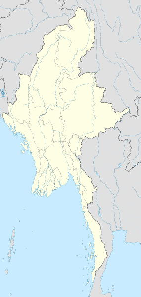
English: Location map of Myanmar. Equirectangular projection. Strechted by 105.0%. Geographic limits of the map: * N: 29.0° N * S: 9.0° N * W: 92.0° E * E: 102.0° E Made with Natural Earth. Free vector and raster map data @ naturalearthdata.com. |
| Petsa | |
| Gigikanan | Kaugalingong trabaho |
| Tagsulat | Uwe Dedering |
Pagtugot
I, the copyright holder of this work, hereby publish it under the following licenses:
This file is licensed under the Creative Commons Attribution-Share Alike 3.0 Unported license.
- Libre ka:
- sa pagsabwag – sa pagkopya, pag-apod-apod ug pagsabwag sa hinimo
- sa pag-remix – sa pag-adap sa binuhat
- Ubos sa mosunod nga mga kondisyon:
- atribusyon – Kinahanglan nimo nga hatagan ang angay nga kredito, maghatag usa ka link sa lisensya, ug ipakita kung adunay mga pagbag-o. Mahimo nimo kini buhaton sa bisan unsang makatarunganon nga paagi, apan dili sa bisan unsang paagi nga nagsugyot nga gi-endorso ka sa licensor o ang imong paggamit.
- share parehas – Kung imong gi-remix, gibag-o, o gibase sa materyal, kinahanglan nimo nga iapod-apod ang imong mga kontribusyon sa ilawom sa parehas o katugma nga lisensya sama sa orihinal.

|
Gitugot ang pagkopya, pag-apud-apod o/ug pag-usab ning maong dokumento ubos sa mga termino sa GNU Free Documentation License, Version 1.2 o mas bag-ong bersiyon nga gimantala sa Free Software Foundation; nga walay Invariant Sections, walay Front-Cover Texts, ug walay Back-Cover Texts. Ang kopya sa lisensiya gilakip sa bahin nga giulohang GNU Free Documentation License. |
You may select the license of your choice.
| Annotations | This image is annotated: View the annotations at Commons |
Kaagi sa payl
I-klik ang petsa/oras aron makit-an ang hulagway sa payl niadtong panahona.
| Petsa/Takna | Thumbnail | Mga dimensyon | Tiggamit | Komento | |
|---|---|---|---|---|---|
| kasamtangan | 16:08, 29 Septiyembre 2011 | | 1,200 × 2,520 (633 KB) | NordNordWest | corr, see disk |
| 17:45, 18 Pebrero 2010 |  | 1,200 × 2,520 (968 KB) | Uwe Dedering | no disputed countries | |
| 13:03, 18 Pebrero 2010 |  | 1,200 × 2,520 (974 KB) | Uwe Dedering | {{Information |Description={{en|1=Location map of Myanmar. Equirectangular projection. Strechted by 105.0%. Geographic limits of the map: * N: 29.0° N * S: 9.0° N * W: 92.0° E * E: 102.0° E Made with Natural Earth. Free vector and raster map dat |
Mga paggamit sa payl
More than 100 pages use this file. The following list shows the first 100 pages that use this file only. A full list is available.
- Adams Island
- Alligator Point
- Amherst
- Bago (pagklaro)
- Bali Chaung
- Beacon Hill
- Black Point
- Black Rock
- Bluff Point
- Boat Rock
- Butler Island
- Castle Island
- Conspicuous Rock
- Cornwall Point
- Creek Point
- Crow Island
- Dagon (pagklaro)
- Dala
- Dome
- Eastern Channel
- Elizabeth Island
- Entrance Island
- Evans Island
- Five Islands
- Flat Island
- Fletcher Island
- Green Island
- Henry Island
- High Island
- High Rock
- Hill Island
- Hodge Point
- Hope Point
- Howard Island
- Kennedy Peak
- Kinda
- King Island
- King Point
- Koku
- Leke
- Ling Chara
- Lion Island
- Long Island
- Magwe
- Martin Island
- Mau Taung
- McCarthy Island
- McLeod Island
- Me
- Middle Bank
- Middle Island
- Mill Point
- Mon
- Money Point
- Monkey Point
- Mouse Island
- North Rocks
- North Spit
- Outer Island
- Pagoda Peak
- Pigeon Island
- Pinnacle Rock
- Pyramid Rock
- Quoin Hill
- Rat Island
- Red Island
- Rocky Point
- Ross Island
- Russel Island
- Russell Island
- Sa
- Sack Island
- Saddle Island
- Sail Rock
- Saint Martins Reef
- Sanda
- Sanders Island
- Sandy Island
- Sandy Point
- Shinan
- South Bay
- South Rock
- South Rocks
- South Spit
- Sugar Loaf
- Table Island
- Tala
- Taung
- Taungnyo
- Tree Island
- Turtle Island
- Victoria Lake
- Victoria Point
- Warrington Island
- West Point
- White Point
- White Rock
- William Island
- Wilson Island
- Wright Island
View more links to this file.
Global nga paggamit sa payl
Kining ubang wiki naggamit ning maong payl:
- Paggamit sa af.wikipedia.org
- Paggamit sa an.wikipedia.org
- Paggamit sa ar.wikipedia.org
- Paggamit sa az.wikipedia.org
- Paggamit sa ba.wikipedia.org
- Paggamit sa be.wikipedia.org
- Paggamit sa bg.wikipedia.org
- Paggamit sa bh.wikipedia.org
- Paggamit sa bn.wikipedia.org
View more global usage of this file.