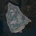
Payl:NASA Worldwind, USGS imagery map, Dutton Island, California.png

Page contents not supported in other languages.
Gikan sa Wikipedia, ang gawasnong ensiklopedya

Tibuok resolusyon(900 × 900 pixels, size sa payl: 1.14 MB, MIME type: image/png)

Kining maong payl gikan sa Wikimedia Commons ug mahimong gigamit sa ubang proyekto. Ang deskripsyon niini didto gipakita sa ubos.

Mubong sugid:

Deskripsyon
English: Aerial photo of an island.
Petsa
Gigikanan NASA tool at worldwind.earth, USGS Topo Imagery map layer
Tagsulat USGS imagery
Pagtugot
(Paggamit pag-usab niini nga file)
Public domain
This image is in the public domain in the United States because it only contains materials that originally came from the United States Geological Survey, an agency of the United States Department of the Interior. For more information, see the official USGS copyright policy.

Bahasa Indonesia  català  čeština  Deutsch  eesti  English  español  français  galego  italiano  Nederlands  português  polski  sicilianu  suomi  Tiếng Việt  Türkçe  български  македонски  русский  മലയാളം  한국어  日本語  中文  中文(简体)  中文(繁體)  العربية  فارسی  +/−

Pagtugot

w:en:Creative Commons
atribusyon share parehas
This file is licensed under the Creative Commons Attribution-Share Alike 4.0 International license.
Libre ka:
  • sa pagsabwag – sa pagkopya, pag-apod-apod ug pagsabwag sa hinimo
  • sa pag-remix – sa pag-adap sa binuhat
Ubos sa mosunod nga mga kondisyon:
  • atribusyon – Kinahanglan nimo nga hatagan ang angay nga kredito, maghatag usa ka link sa lisensya, ug ipakita kung adunay mga pagbag-o. Mahimo nimo kini buhaton sa bisan unsang makatarunganon nga paagi, apan dili sa bisan unsang paagi nga nagsugyot nga gi-endorso ka sa licensor o ang imong paggamit.
  • share parehas – Kung imong gi-remix, gibag-o, o gibase sa materyal, kinahanglan nimo nga iapod-apod ang imong mga kontribusyon sa ilawom sa parehas o katugma nga lisensya sama sa orihinal.

Captions

Add a one-line explanation of what this file represents

Items portrayed in this file

depicts English

copyrighted English

16 Septiyembre 2020

Kaagi sa payl

I-klik ang petsa/oras aron makit-an ang hulagway sa payl niadtong panahona.

Petsa/TaknaThumbnailMga dimensyonTiggamitKomento
kasamtangan02:11, 23 Pebrero 2021Thumbnail sa bersyon sa 02:11, 23 Pebrero 2021900 × 900 (1.14 MB)JPxGabsolutely cannot stop messing with this
02:09, 23 Pebrero 2021Thumbnail sa bersyon sa 02:09, 23 Pebrero 2021900 × 900 (1.14 MB)JPxGmight as well just make an actually good one instead at this point
01:50, 23 Pebrero 2021Thumbnail sa bersyon sa 01:50, 23 Pebrero 2021200 × 250 (79 KB)JPxGMake border more clear
01:47, 23 Pebrero 2021Thumbnail sa bersyon sa 01:47, 23 Pebrero 2021200 × 250 (78 KB)JPxGDefine boundary and crop to fit, per reclamation district and USGS survey maps
06:40, 17 Septiyembre 2020Thumbnail sa bersyon sa 06:40, 17 Septiyembre 2020537 × 462 (380 KB)JPxG{{Information |description ={{en|1=Aerial photo of an island.}} |date =2020-09-16 |source =NASA tool at worldwind.earth, USGS Topo Imagery map layer |author =USGS imagery |permission ={{PD-USGov-USGS}} }} Category:Islands of California

Ang mosunod nga mga panid misumpay niining payl:

Global nga paggamit sa payl

Kining ubang wiki naggamit ning maong payl:

Metadata