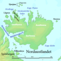
Payl:Nordaustlandet labelled.png

Page contents not supported in other languages.
Gikan sa Wikipedia, ang gawasnong ensiklopedya

Nordaustlandet_labelled.png(524 × 528 pixels, size sa payl: 119 KB, MIME type: image/png)

Kining maong payl gikan sa Wikimedia Commons ug mahimong gigamit sa ubang proyekto. Ang deskripsyon niini didto gipakita sa ubos.

Mubong sugid:

Deskripsyon
English: Map detailing the marine features of Spitsbergen in the Svalbard archipelago. Settlements and mountains are indicated and labelled. See also Image:Spitsbergen mountains and marine features labelled.png. Locations were labelled mainly based on detailed maps from svalbard-images.com (sample of south Spitsbergen linked), cross-referenced with other map sources where possible. Norwegian Polar Institute figures were used for mountain names and heights, which are given in meters above sea level.
Petsa 29 Hulyo 2006 (original upload date)
Gigikanan No machine-readable source provided. Own work assumed (based on copyright claims).
Tagsulat No machine-readable author provided. TheGrappler assumed (based on copyright claims).

Pagtugot

DEMIS World Map Server archive copy at the Wayback Machine generated this map from Public Domain sources. DEMIS does not claim any rights over the resultant image ([1] archive copy at the Wayback Machine). Alterations, including the addition of settlements and captions, were performed on 24 July 2006 by User:TheGrappler, the uploader, who releases all associated rights.

Public domain I, the copyright holder of this work, release this work into the public domain. This applies worldwide.
In some countries this may not be legally possible; if so:
I grant anyone the right to use this work for any purpose, without any conditions, unless such conditions are required by law.
Public domain
This image is in the public domain because it came from the site https://www.demis.nl/products/web-map-server/examples/ and was released by the copyright holder. Permission is granted to copy, distribute and/or modify this map since it is based on free of copyright images from: www.demis.nl. See also approval email on de.wp and its clarification.

Deutsch | English | македонски | മലയാളം | Nederlands | slovenščina | +/−

Public domain This work has been released into the public domain by its copyright holder, www.demis.nl. This applies worldwide.
In some countries this may not be legally possible; if so:
www.demis.nl grants anyone the right to use this work for any purpose, without any conditions, unless such conditions are required by law.


derivative works

Derivative works of this file:  Wilhelmøya.PNG

Captions

Add a one-line explanation of what this file represents

Items portrayed in this file

depicts English

29 Hulyo 2006

Kaagi sa payl

I-klik ang petsa/oras aron makit-an ang hulagway sa payl niadtong panahona.

Petsa/TaknaThumbnailMga dimensyonTiggamitKomento
kasamtangan02:47, 29 Hulyo 2006Thumbnail sa bersyon sa 02:47, 29 Hulyo 2006524 × 528 (119 KB)TheGrapplerRemove cursor
01:08, 29 Hulyo 2006Thumbnail sa bersyon sa 01:08, 29 Hulyo 2006524 × 528 (119 KB)TheGrapplerCorrect spelling
00:40, 29 Hulyo 2006Thumbnail sa bersyon sa 00:40, 29 Hulyo 2006524 × 528 (119 KB)TheGrappler== Summary == {{English}} Map detailing the marine features of Spitsbergen in the Svalbard archipelago. Settlements and mountains are indicated and labelled. See also Image:Spitsbergen mountains and marine features labelled.png. Locations were labell

Ang mosunod nga 2 panid misumpay niining payl:

Global nga paggamit sa payl