
Payl:Norway Hordaland location map.svg

Tibuok resolusyon (SVG nga payl, nominally 939 × 912 pixels, size sa payl: 267 KB)
Mubong sugid:
| Deskripsyon |
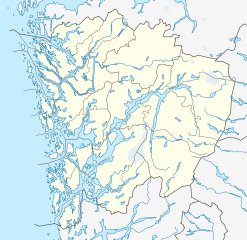
Quadratische Plattkarte, N-S-Streckung 200 %. Geographische Begrenzung der Karte:
Equirectangular projection, N/S stretching 200 %. Geographic limits of the map:
|
|
| Petsa | ||
| Gigikanan |
Kaugalingong trabaho, using
|
|
| Tagsulat | NordNordWest | |
| Pagtugot (Paggamit pag-usab niini nga file) |
This file is licensed under the Creative Commons Attribution-Share Alike 3.0 Germany license.
 This file is licensed under the Creative Commons Attribution-Share Alike 3.0 Germany license.
|


|
This map has been made or improved in the German Kartenwerkstatt (Map Lab). You can propose maps to improve as well.
|
Kaagi sa payl
I-klik ang petsa/oras aron makit-an ang hulagway sa payl niadtong panahona.
| Petsa/Takna | Thumbnail | Mga dimensyon | Tiggamit | Komento | |
|---|---|---|---|---|---|
| kasamtangan | 13:53, 24 Mayo 2010 | | 939 × 912 (267 KB) | NordNordWest | ={{int:filedesc}}== {{Information |Description= {{de|Positionskarte von Hordaland, Norwegen}} Quadratische Plattkarte, N-S-Streckung 200 %. Geographische Begrenzung der Karte: * N: 61.1° N * S: 59.4° N * W: 4.4° O * O |
Mga paggamit sa payl
Ang mosunod nga mga panid misumpay niining payl:
Global nga paggamit sa payl
Kining ubang wiki naggamit ning maong payl:
- Paggamit sa ar.wikipedia.org
- Paggamit sa ba.wikipedia.org
- Paggamit sa bg.wikipedia.org
- Paggamit sa cs.wikipedia.org
- Paggamit sa da.wikipedia.org
- Paggamit sa de.wikipedia.org
- Paggamit sa en.wikipedia.org
- Paggamit sa eo.wikipedia.org
View more global usage of this file.