
Payl:Oceans and seas boundaries map-en.svg

Size of this PNG preview of this SVG file: 800 x 406 ka mga piksel. Uban pang mga resoluyon: 320 x 162 ka mga piksel | 640 x 325 ka mga piksel | 1,024 x 519 ka mga piksel | 1,280 x 649 ka mga piksel | 2,560 x 1,299 ka mga piksel | 4,000 x 2,029 ka mga piksel.
Tibuok resolusyon (SVG nga payl, nominally 4,000 × 2,029 pixels, size sa payl: 1.39 MB)
Mubong sugid:
| Deskripsyon |
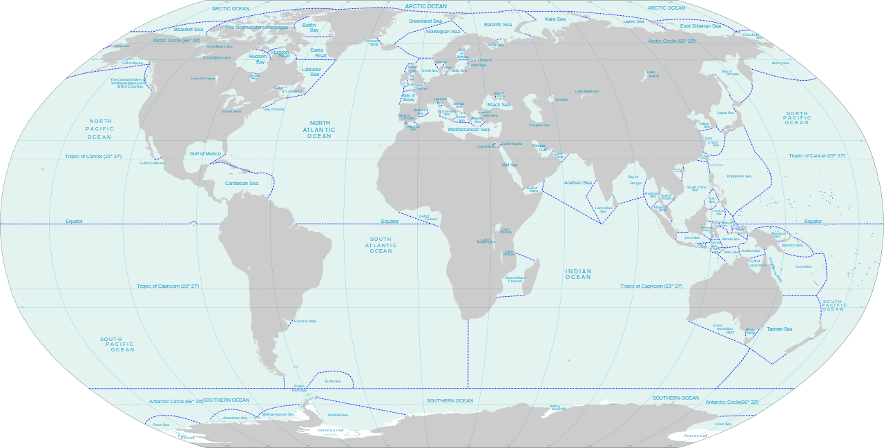
English: World map of oceans and seas : English version |
| Petsa | (UTC) |
| Gigikanan |
Own work using:
|
| Tagsulat | |
| Other versions | Turkish version, French version |
| This is a retouched picture, which means that it has been digitally altered from its original version. Modifications: Translated remaining French labels, fixed some English labels, added missing sea and lake names, added missing lake, refactored text styling of some labels to match the rest, fixed rainbow of colors assigned to random islands, added missing Malta and Bermuda islands. The original can be viewed here: Oceans and seas boundaries map-en.svg:
|
I, the copyright holder of this work, hereby publish it under the following licenses:
This file is licensed under the Creative Commons Attribution-Share Alike 3.0 Unported, 2.5 Generic, 2.0 Generic and 1.0 Generic license.
- Libre ka:
- sa pagsabwag – sa pagkopya, pag-apod-apod ug pagsabwag sa hinimo
- sa pag-remix – sa pag-adap sa binuhat
- Ubos sa mosunod nga mga kondisyon:
- atribusyon – Kinahanglan nimo nga hatagan ang angay nga kredito, maghatag usa ka link sa lisensya, ug ipakita kung adunay mga pagbag-o. Mahimo nimo kini buhaton sa bisan unsang makatarunganon nga paagi, apan dili sa bisan unsang paagi nga nagsugyot nga gi-endorso ka sa licensor o ang imong paggamit.
- share parehas – Kung imong gi-remix, gibag-o, o gibase sa materyal, kinahanglan nimo nga iapod-apod ang imong mga kontribusyon sa ilawom sa parehas o katugma nga lisensya sama sa orihinal.

|
Gitugot ang pagkopya, pag-apud-apod o/ug pag-usab ning maong dokumento ubos sa mga termino sa GNU Free Documentation License, Version 1.2 o mas bag-ong bersiyon nga gimantala sa Free Software Foundation; nga walay Invariant Sections, walay Front-Cover Texts, ug walay Back-Cover Texts. Ang kopya sa lisensiya gilakip sa bahin nga giulohang GNU Free Documentation License. |
You may select the license of your choice.
Original upload log
This image is a derivative work of the following images:
- File:Oceans and seas boundaries map-fr.svg licensed with Cc-by-sa-3.0,2.5,2.0,1.0, GFDL
- 2021-04-05T01:32:50Z Dziban303 2753x1538 (1276318 Bytes) == {{int:filedesc}} == {{Information |Description={{en|World map of oceans and seas : English version}} |Source={{Derived from|Oceans and seas boundaries map-en.svg|display=50}} |Date=2021-04-05 01:09 (UTC) |Author=* [[:File:
- 2021-04-04T21:12:48Z Dziban303 2753x1538 (1268270 Bytes) == {{int:filedesc}} == {{Information |Description=English: World map of oceans and seas : English version|Source={{Derived from|Oceans and seas boundaries map-en.svg|display=50}} |Date=2021-04-04 21:10 (UTC) |Author=* [[:File:
- 2011-02-13T11:57:29Z Jugger90 2753x1538 (1263323 Bytes) {{Information |Description={{en|World map of oceans and seas : french version}} {{fr|Carte des océans et des mers du monde : version vide}} |Source=*[[:File:Oceans_and_seas_boundaries_map-fr.svg|]] |Date=2011-02-13 11:56 (UT
Uploaded with derivativeFX
Kaagi sa payl
I-klik ang petsa/oras aron makit-an ang hulagway sa payl niadtong panahona.
| Petsa/Takna | Thumbnail | Mga dimensyon | Tiggamit | Komento | |
|---|---|---|---|---|---|
| kasamtangan | 14:11, 11 Hunyo 2021 | | 4,000 × 2,029 (1.39 MB) | Ibrahim Muizzuddin | Edit toponymy, resize |
| 13:35, 11 Hunyo 2021 |  | 2,753 × 1,396 (1.22 MB) | Ibrahim Muizzuddin | Fit image | |
| 02:13, 5 Abril 2021 |  | 2,753 × 1,538 (1.22 MB) | Dziban303 | == {{int:filedesc}} == {{Information |Description={{en|World map of oceans and seas — English version}} |Source={{Derived from|Oceans and seas boundaries map-en.svg|display=50}} |Date=2021-04-05 02:11 (UTC) |Author=* File:Oceans and seas boundaries map-en.svg: *Oceans_and_seas_boundaries_map-fr.svg: Pinpin * derivative work: Jugger90 ([[User talk:Jugger90|<span cla... | |
| 01:32, 5 Abril 2021 |  | 2,753 × 1,538 (1.22 MB) | Dziban303 | == {{int:filedesc}} == {{Information |Description={{en|World map of oceans and seas : English version}} |Source={{Derived from|Oceans and seas boundaries map-en.svg|display=50}} |Date=2021-04-05 01:09 (UTC) |Author=* File:Oceans and seas boundaries map-en.svg: *Oceans_and_seas_boundaries_map-fr.svg: Pinpin *derivative work: Jugger90 ([[User talk:Jugger90|<span clas... | |
| 21:12, 4 Abril 2021 |  | 2,753 × 1,538 (1.21 MB) | Dziban303 | == {{int:filedesc}} == {{Information |Description={{en|World map of oceans and seas : English version}} |Source={{Derived from|Oceans and seas boundaries map-en.svg|display=50}} |Date=2021-04-04 21:10 (UTC) |Author=* File:Oceans and seas boundaries map-en.svg: *Oceans_and_seas_boundaries_map-fr.svg: Pinpin *derivative work: Jugger90 ([[User talk:Jugger90|<span clas... | |
| 11:57, 13 Pebrero 2011 |  | 2,753 × 1,538 (1.2 MB) | Jugger90 | {{Information |Description={{en|World map of oceans and seas : french version}} {{fr|Carte des océans et des mers du monde : version vide}} |Source=*File:Oceans_and_seas_boundaries_map-fr.svg |Date=2011-02-13 11:56 (UTC) |Author=*[[:File:Oceans_and |
Mga paggamit sa payl
Ang mosunod nga mga panid misumpay niining payl:
Global nga paggamit sa payl
Kining ubang wiki naggamit ning maong payl:
- Paggamit sa ar.wikipedia.org
- Paggamit sa ast.wikipedia.org
- Paggamit sa bh.wikipedia.org
- Paggamit sa blk.wikipedia.org
- Paggamit sa bs.wikipedia.org
- Paggamit sa da.wikipedia.org
- Paggamit sa de.wikipedia.org
- Paggamit sa el.wikipedia.org
- Paggamit sa en.wikipedia.org
- Paggamit sa eo.wikipedia.org
- Paggamit sa es.wikipedia.org
- Paggamit sa eu.wikipedia.org
- Paggamit sa fa.wikipedia.org
- Paggamit sa fi.wikipedia.org
- Paggamit sa id.wikipedia.org
- Paggamit sa ilo.wikipedia.org
- Paggamit sa it.wikipedia.org
- Paggamit sa ka.wikipedia.org
- Paggamit sa kn.wikipedia.org
- Paggamit sa mk.wikipedia.org
- Paggamit sa mn.wikipedia.org
- Paggamit sa mr.wikipedia.org
- Paggamit sa ms.wikipedia.org
- Paggamit sa ru.wikipedia.org
- Paggamit sa sh.wikipedia.org
- Paggamit sa sl.wikipedia.org
- Paggamit sa sn.wikipedia.org
- Paggamit sa sv.wikipedia.org
- Paggamit sa th.wikipedia.org
- Paggamit sa ur.wikipedia.org
- Paggamit sa vi.wikipedia.org
- Paggamit sa zh.wikipedia.org