
Payl:Ostrya virginiana range map.jpg
Gidak-on ning maong paunang tan-aw: 463 x 600 ka mga piksel. Uban pang mga resoluyon: 185 x 240 ka mga piksel | 556 x 720 ka mga piksel.
Tibuok resolusyon (556 × 720 pixels, size sa payl: 64 KB, MIME type: image/jpeg)
Mubong sugid:
| Deskripsyon |
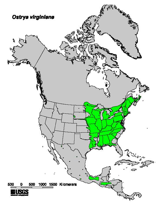
English: Natural range map of Ostrya virginiana — American Hophornbeam. |
| Gigikanan | Digital representation of "Atlas of United States Trees" by Elbert L. Little, Jr. 1999. U.S. Geological Survey. [1] |
| Tagsulat | Elbert L. Little, Jr. |
| Other versions |
_Ostrya_virginiana_(20966300102).jpg) |


Pagtugot
This image is in the public domain in the United States because it only contains materials that originally came from the United States Geological Survey, an agency of the United States Department of the Interior. For more information, see the official USGS copyright policy.
|
Original upload log
The original description page was here. All following user names refer to en.wikipedia.
- 2010-04-18 11:42 Pinethicket 556×720× (65321 bytes) Natural range of American Hophornbeam (''Ostrya virginiana''). Digital representation of "Atlas of United States Trees" by Elbert L. Little, Jr. 1999. U.S. Geological Survey. [http://esp.cr.usgs.gov/data/atlas/little/]
Kaagi sa payl
I-klik ang petsa/oras aron makit-an ang hulagway sa payl niadtong panahona.
| Petsa/Takna | Thumbnail | Mga dimensyon | Tiggamit | Komento | |
|---|---|---|---|---|---|
| kasamtangan | 17:28, 3 Disyembre 2010 | | 556 × 720 (64 KB) | GreenZmiy | {{Information |Description={{en|Natural range of American Hophornbeam (''Ostrya virginiana''). Digital representation of "Atlas of United States Trees" by Elbert L. Little, Jr. 1999. U.S. Geological Survey. [http://esp.cr.usgs.gov/data/atlas/little/]}} |
Mga paggamit sa payl
Ang mosunod nga mga panid misumpay niining payl:
Global nga paggamit sa payl
Kining ubang wiki naggamit ning maong payl:
- Paggamit sa arz.wikipedia.org
- Paggamit sa cs.wikipedia.org
- Paggamit sa en.wikipedia.org
- Paggamit sa es.wikipedia.org
- Paggamit sa fr.wikipedia.org
- Paggamit sa ig.wikipedia.org
- Paggamit sa no.wikipedia.org
- Paggamit sa pl.wikipedia.org
- Paggamit sa pt.wikipedia.org
- Paggamit sa ru.wikipedia.org
- Paggamit sa sv.wikipedia.org
- Paggamit sa vi.wikipedia.org
- Paggamit sa www.wikidata.org