
Payl:Royal Parade - geograph.org.uk - 1530906.jpg
Walay mas taas nga resolusyon.
Royal_Parade_-_geograph.org.uk_-_1530906.jpg (640 × 426 pixels, size sa payl: 100 KB, MIME type: image/jpeg)
Mubong sugid:
| Deskripsyon |
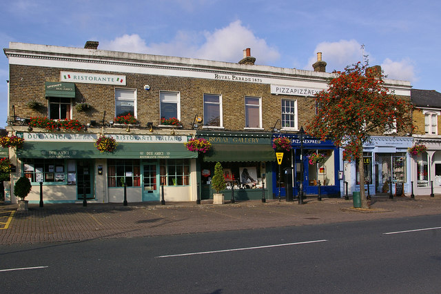
English: Royal Parade Built in the 1860s, it was named Royal Parade in the 1870s, not because of Queen Victoria but because of its connection with Napoleon III whose family moved into nearby Camden Place in 1870 (hence the 1870 alongside the words Royal Parade along the top of the building here). The family moved there following Napoleon's defeat and capture in the Battle of Sedan and subsequent removal as Emperor, with the deposed Emperor himself moving there in exile in 1871. |
| Petsa | |
| Gigikanan | From geograph.org.uk |
| Tagsulat | Ian Capper |
| Attribution (required by the license) | Ian Capper / Royal Parade / |
| Camera location | | View this and other nearby images on: OpenStreetMap |
|---|
_heading:247.00&language=ceb)
| Object location | | View this and other nearby images on: OpenStreetMap |
|---|
_heading:247.00&language=ceb)
Pagtugot

|
This image was taken from the Geograph project collection. See this photograph's page on the Geograph website for the photographer's contact details. The copyright on this image is owned by Ian Capper and is licensed for reuse under the Creative Commons Attribution-ShareAlike 2.0 license.
|
This file is licensed under the Creative Commons Attribution-Share Alike 2.0 Generic license.
Attribution: Ian Capper
- Libre ka:
- sa pagsabwag – sa pagkopya, pag-apod-apod ug pagsabwag sa hinimo
- sa pag-remix – sa pag-adap sa binuhat
- Ubos sa mosunod nga mga kondisyon:
- atribusyon – Kinahanglan nimo nga hatagan ang angay nga kredito, maghatag usa ka link sa lisensya, ug ipakita kung adunay mga pagbag-o. Mahimo nimo kini buhaton sa bisan unsang makatarunganon nga paagi, apan dili sa bisan unsang paagi nga nagsugyot nga gi-endorso ka sa licensor o ang imong paggamit.
- share parehas – Kung imong gi-remix, gibag-o, o gibase sa materyal, kinahanglan nimo nga iapod-apod ang imong mga kontribusyon sa ilawom sa parehas o katugma nga lisensya sama sa orihinal.
Kaagi sa payl
I-klik ang petsa/oras aron makit-an ang hulagway sa payl niadtong panahona.
| Petsa/Takna | Thumbnail | Mga dimensyon | Tiggamit | Komento | |
|---|---|---|---|---|---|
| kasamtangan | 07:26, 3 Marso 2011 | | 640 × 426 (100 KB) | GeographBot | == {{int:filedesc}} == {{Information |description={{en|1=Royal Parade Built in the 1860s, it was named Royal Parade in the 1870s, not because of Queen Victoria but because of its connection with Napoleon III whose family moved into nearby Camden Place in |
Mga paggamit sa payl
Ang mosunod nga mga panid misumpay niining payl:
Global nga paggamit sa payl
Kining ubang wiki naggamit ning maong payl:
- Paggamit sa azb.wikipedia.org
- Paggamit sa cy.wikipedia.org
- Paggamit sa en.wikipedia.org
- Paggamit sa fa.wikipedia.org
- Paggamit sa fr.wikipedia.org
- Paggamit sa he.wikipedia.org
- Paggamit sa pt.wikipedia.org
- Paggamit sa www.wikidata.org
- Paggamit sa zh.wikipedia.org