
Payl:São Tomé and Príncipe location map.svg

Size of this PNG preview of this SVG file: 428 x 599 ka mga piksel. Uban pang mga resoluyon: 171 x 240 ka mga piksel | 343 x 480 ka mga piksel | 549 x 768 ka mga piksel | 732 x 1,024 ka mga piksel | 1,464 x 2,048 ka mga piksel | 496 x 694 ka mga piksel.
Tibuok resolusyon (SVG nga payl, nominally 496 × 694 pixels, size sa payl: 10 KB)
Mubong sugid:
| Deskripsyon |
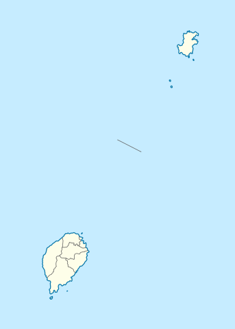
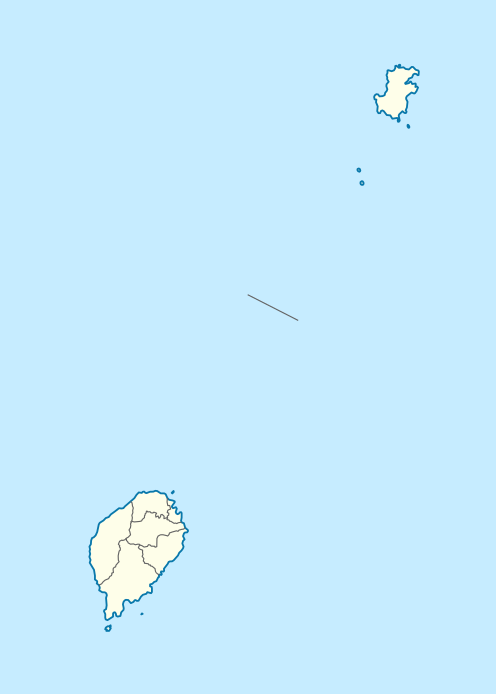
Deutsch: Positionskarte von São Tomé and Príncipe
Quadratische Plattkarte. Geographische Begrenzung der Karte:
English: Location map of São Tomé and Príncipe
Equirectangular projection. Geographic limits of the map:
|
| Petsa | |
| Gigikanan |
Kaugalingong trabaho, using
|
| Tagsulat | NordNordWest |
| Pagtugot (Paggamit pag-usab niini nga file) |
I, the copyright holder of this work, hereby publish it under the following license: This file is licensed under the Creative Commons Attribution-Share Alike 3.0 Unported license.
|

|
This map has been made or improved in the German Kartenwerkstatt (Map Lab). You can propose maps to improve as well.
|
Kaagi sa payl
I-klik ang petsa/oras aron makit-an ang hulagway sa payl niadtong panahona.
| Petsa/Takna | Thumbnail | Mga dimensyon | Tiggamit | Komento | |
|---|---|---|---|---|---|
| kasamtangan | 19:01, 27 Nobiyembre 2020 | | 496 × 694 (10 KB) | NordNordWest | more exact |
| 15:25, 17 Hunyo 2014 |  | 496 × 694 (9 KB) | NordNordWest | corr | |
| 19:40, 5 Oktubre 2009 |  | 496 × 694 (13 KB) | NordNordWest | {{int:filedesc}} {{Information |Description= {{de|Positionskarte von São Tomé and Príncipe}} Quadratische Plattkarte. Geographische Begrenzung der Karte: * N: 1.9° N * S: 0.2° S * W: 6.2° E * O: 7.7° E {{en|Location |
Mga paggamit sa payl
More than 100 pages use this file. The following list shows the first 100 pages that use this file only. A full list is available.
- Agua Canoa
- Agua Grande
- Aida
- Aliança
- António Enes
- Baia de Santo Antonio
- Baliza
- Batalha
- Baía da Praia Grande
- Baía do Almoxarife
- Binda
- Botija
- Calvario
- Cambuta
- Cantagalo
- Capitango
- Castelo
- Catraio
- Celeste
- Conceicao
- Conceição
- Cruzeiro
- Dutchman’s Cap
- Esperança
- Estoril
- Ilha de São Tomé
- Little Brother
- Maria Helena
- Micondo
- Monte Castro
- Monte Cristo
- Monte Sinai
- Monteverde
- Morro Cantagalo
- Morro São Francisco
- Morro da Trindade
- Muongo
- Mutamba
- Nova Olinda
- Observatorio
- Palmira
- Pedra Furada
- Pedra da Galé
- Pico Negro
- Picão
- Pinheiro
- Ponta Agua
- Ponta Baleia
- Ponta Furada
- Ponta Garça
- Ponta Pedrinha
- Ponta Prainha
- Ponta da Agulha
- Ponta da Garça
- Ponta da Mina
- Ponta de Santo Antonio
- Ponta de Santo António
- Ponta dos Mosteiros
- Praia Grande
- Praia Pequena
- Praia da Fortaleza
- Praia das Conchas
- Praia de Santa Rita
- Praia do Forno
- Ribeira Funda
- Ribeira de Frades
- Rio Campos
- Rio Caue
- Rio Contador
- Rio Maria Luisa
- Rio Melo
- Rio Papagaio
- Rio Sao Joao
- Rio São João
- Rio São Miguel
- Rio das Pedras
- Rio do Ouro
- Safu
- Saint Thomas Island
- Salazar
- Sameiro
- San Antonio
- Santa Catarina
- Santana
- Santo Antonio
- Santo António
- Sao Francisco
- Sao Joao
- Sao Pedro
- Sao Tome
- Seven Stones
- Sintra
- São Francisco
- São João
- São Manuel
- São Pedro
- São Tomé
- The Brothers
- Trindade
- Água Grande
View more links to this file.
Global nga paggamit sa payl
Kining ubang wiki naggamit ning maong payl:
- Paggamit sa af.wikipedia.org
- Paggamit sa am.wikipedia.org
- Paggamit sa an.wikipedia.org
- Paggamit sa ar.wikipedia.org
- Paggamit sa ast.wikipedia.org
- Paggamit sa ba.wikipedia.org
- Paggamit sa be-tarask.wikipedia.org
- Paggamit sa be.wikipedia.org
- Paggamit sa bg.wikipedia.org
- Paggamit sa bn.wikipedia.org
- Paggamit sa bs.wikipedia.org
- Paggamit sa ca.wikipedia.org
- Paggamit sa ce.wikipedia.org
- Paggamit sa ckb.wikipedia.org
- Paggamit sa cs.wikipedia.org
- Paggamit sa da.wikipedia.org
- Paggamit sa de.wikipedia.org
- São Tomé
- Ilhéu Bom Bom
- Príncipe
- Pico de São Tomé
- Santo Amaro (São Tomé und Príncipe)
- Cantagalo (Distrikt)
- Santana (São Tomé und Príncipe)
- Flughafen Príncipe
- Vorlage:Positionskarte São Tomé und Príncipe
- Wikipedia:Kartenwerkstatt/Positionskarten/Afrika
- Flughafen São Tomé
- Ilhéu das Cabras
- Tinhosa Grande
- Tinhosa Pequena
- Santo António (Príncipe)
- Ilhéu Caroço
View more global usage of this file.