
Payl:SAM pol.png

Tibuok resolusyon (976 × 1,059 pixels, size sa payl: 558 KB, MIME type: image/png)
Permission is granted to copy, distribute and/or modify this document under the terms of the GNU Free Documentation License, Version 1.2 or any later version published by the Free Software Foundation; with no Invariant Sections, no Front-Cover Texts, and no Back-Cover Texts. A copy of the license is included in the section entitled GNU Free Documentation License.
Mubong sugid:
| Deskripsyon |
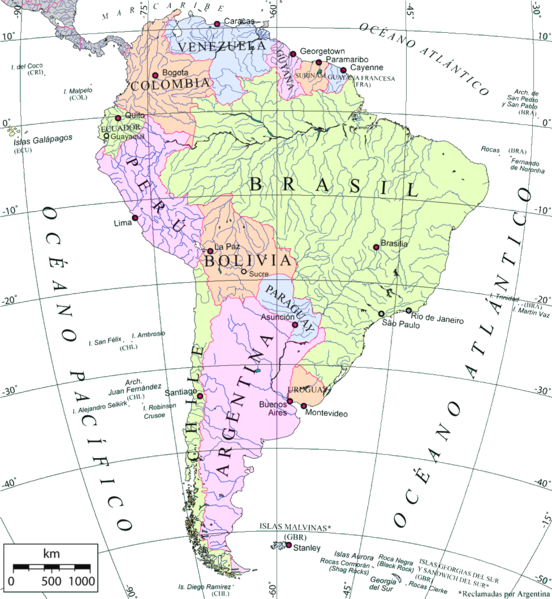
Mapa político de América del Sur en español, capitales, 2 ciudades mayores de Brasil, islas periféricas, ríos. Proyección azimutal equivalente. Political map of South America in spanish, capitals, 2 biggest cities of Brazil, periferical islands, rivers. Azimuthal equal-area Projection |
| Petsa | |
| Gigikanan | Own work over an OMC base map |
| Tagsulat | Giovanni Fattori, using OMC base map |
| Pagtugot (Paggamit pag-usab niini nga file) |
Free license |
Pagtugot

|
Gitugot ang pagkopya, pag-apud-apod o/ug pag-usab ning maong dokumento ubos sa mga termino sa GNU Free Documentation License, Version 1.2 o mas bag-ong bersiyon nga gimantala sa Free Software Foundation; nga walay Invariant Sections, walay Front-Cover Texts, ug walay Back-Cover Texts. Ang kopya sa lisensiya gilakip sa bahin nga giulohang GNU Free Documentation License. |
| This file is licensed under the Creative Commons Attribution-Share Alike 3.0 Unported license. | ||
| ||
| This licensing tag was added to this file as part of the GFDL licensing update. |
Kaagi sa payl
I-klik ang petsa/oras aron makit-an ang hulagway sa payl niadtong panahona.
| Petsa/Takna | Thumbnail | Mga dimensyon | Tiggamit | Komento | |
|---|---|---|---|---|---|
| kasamtangan | 14:48, 28 Mayo 2007 | | 976 × 1,059 (558 KB) | Pruxo | {{Information |Description=Mapa político de América del Sur en español, capitales, 2 ciudades mayores de Brasil, 1 de ecuador, 1 de bolivia, islas periféricas, ríos. Proyección azimutal equivalente. |Source=trabajo propio sobre el Own work over an |
| 02:30, 30 Marso 2007 |  | 976 × 1,059 (676 KB) | Gi | {{Information |Description= Mapa político de América del Sur en español, capitales, 2 ciudades mayores de Brasil, islas periféricas, ríos. Proyección azimutal equivalente. Political map of South America in spanish, capitals, 2 biggest cities of Braz | |
| 23:24, 17 Marso 2007 |  | 976 × 1,059 (676 KB) | Gi | {{Information |Description= Mapa político de América del Sur en español, capitales, 2 ciudades mayores de Brasil, islas periféricas, ríos. Proyección azimutal equivalente. Political map of South America in spanish, capitals, 2 biggest cities of Braz |
Mga paggamit sa payl
There are no pages that use this file.
Global nga paggamit sa payl
Kining ubang wiki naggamit ning maong payl:
- Paggamit sa es.wikipedia.org
- Paggamit sa io.wikipedia.org
- Paggamit sa pnb.wikipedia.org
- Paggamit sa sr.wikipedia.org