
Payl:Saint-Barthélemy collectivity location map with quartiers.svg

Size of this PNG preview of this SVG file: 800 x 526 ka mga piksel. Uban pang mga resoluyon: 320 x 210 ka mga piksel | 640 x 420 ka mga piksel | 1,024 x 673 ka mga piksel | 1,280 x 841 ka mga piksel | 2,560 x 1,682 ka mga piksel | 1,175 x 772 ka mga piksel.
Tibuok resolusyon (SVG nga payl, nominally 1,175 × 772 pixels, size sa payl: 135 KB)
Mubong sugid:
| Camera location | | View this and other nearby images on: OpenStreetMap |
|---|
| Deskripsyon |
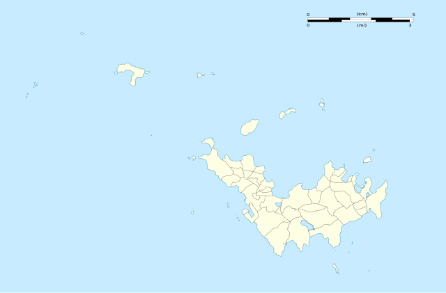
English: Blank administrative map of the overseas collectivity of Saint Barthélemy, France, with Quartiers boundaries, for geo-location purpose.
Français : Carte administrative vierge de la collectivité d'outre-mer de Saint-Barthélemy, France, avec limites des quartiers, destinée à la géolocalisation. Estimated scales: 1:200,000 (precision: 50 m)
Geographic limits of the map:
|
||
| Petsa | |||
| Gigikanan |
Kaugalingong trabaho
|
||
| Tagsulat | Eric Gaba (Sting - fr:Sting) | ||
| Pagtugot (Paggamit pag-usab niini nga file) |
|
||
| Other versions |
|


Pagtugot
Eric Gaba, Wikimedia Commons user Sting, the copyright holder of this work, hereby publishes it under the following licenses:
This file is licensed under the Creative Commons Attribution-Share Alike 3.0 Unported license.
Attribution: Eric Gaba, Wikimedia Commons user Sting
- Libre ka:
- sa pagsabwag – sa pagkopya, pag-apod-apod ug pagsabwag sa hinimo
- sa pag-remix – sa pag-adap sa binuhat
- Ubos sa mosunod nga mga kondisyon:
- atribusyon – Kinahanglan nimo nga hatagan ang angay nga kredito, maghatag usa ka link sa lisensya, ug ipakita kung adunay mga pagbag-o. Mahimo nimo kini buhaton sa bisan unsang makatarunganon nga paagi, apan dili sa bisan unsang paagi nga nagsugyot nga gi-endorso ka sa licensor o ang imong paggamit.
- share parehas – Kung imong gi-remix, gibag-o, o gibase sa materyal, kinahanglan nimo nga iapod-apod ang imong mga kontribusyon sa ilawom sa parehas o katugma nga lisensya sama sa orihinal.

|
Gitugot ang pagkopya, pag-apud-apod o/ug pag-usab ning maong dokumento ubos sa mga termino sa GNU Free Documentation License, Version 1.2 o mas bag-ong bersiyon nga gimantala sa Free Software Foundation; nga walay Invariant Sections, walay Front-Cover Texts, ug walay Back-Cover Texts. Ang kopya sa lisensiya gilakip sa bahin nga giulohang GNU Free Documentation License. |
You may select the license of your choice.
Kaagi sa payl
I-klik ang petsa/oras aron makit-an ang hulagway sa payl niadtong panahona.
| Petsa/Takna | Thumbnail | Mga dimensyon | Tiggamit | Komento | |
|---|---|---|---|---|---|
| kasamtangan | 02:01, 26 Pebrero 2010 | | 1,175 × 772 (135 KB) | Sting | == {{int:filedesc}} == {{Location|17|55|30|N|62|51|45|W|scale:50000}} <br/> {{Information |Description={{en|Blank administrative map of the overseas collectivity of Saint Barthélemy, [[:en:France|Fr |
Mga paggamit sa payl
Ang mosunod nga 84 panid misumpay niining payl:
- Anse Corossol
- Anse du Colombier
- Baie de Saint-Jean
- Baie de Saint-Jean (luuk sa San Bartolomeyo)
- Baie des Flamands
- Baie des Flamands (luuk sa San Bartolomeyo)
- Barrel of Beef
- Canal de l'Ouest
- Canal de l'Ouest (agianan)
- Canal du Sud
- Canal du Sud-Est
- Canal du Sud (agianan)
- Fourche
- Fourmis
- Goat Island
- Grande Pointe
- Grande Pointe (punta sa San Bartolomeyo)
- Groupers
- Gustaf
- Gustavia (ulohang dakbayan sa San Bartolomeyo)
- Ile Coco
- Ile Fregate
- L'Âne Rouge
- La Baleine (bato sa San Bartolomeyo)
- La Baleine (pagklaro)
- La Poule et les Poussins
- La Tortue
- La Tortue (pulo sa San Bartolomeyo)
- Le Boeuf
- Le Carénage
- Le Carénage (luuk)
- Le Pain de Sucre
- Le Pain de Sucre (pulo sa San Bartolomeyo)
- Les Baleines
- Les Baleines (mga bato sa San Bartolomeyo)
- Les Grenadins
- Les Gros Îlets
- Les Islettes (pagklaro)
- Les Saintes
- Les Saintes (kapuloan sa San Bartolomeyo)
- Morne Lurin
- Morne de Grand Fond
- Morne du Vitet
- Pointe Colombier
- Pointe Lorient
- Pointe Lézarde
- Pointe Lézarde (punta sa San Bartolomeyo)
- Pointe Milou
- Pointe Negre
- Pointe Nègre
- Pointe Nègre (punta sa San Bartolomeyo)
- Pointe du Gouvernour
- Pointe du Précipice
- Pointe à Colombier
- Pointe à Corossol
- Pointe à Toigny
- Pointe à Étages
- Roche Baleine
- Roche Table
- Roche le Bœuf
- Roches Rouges
- Roches Rouges (mga bato sa San Bartolomeyo)
- Roques (pagklaro)
- Saint-Barthélemy (pagklaro)
- Saint Barthelemy
- Saint Bartholomew Island
- South Channel
- Southeast Channel
- Sugarloaf
- West Channel
- Île Chevreau
- Île Coco
- Île Fourchue
- Île Frégate
- Île Frégate (pulo sa San Bartolomeyo)
- Île Pelé
- Île Saint-Barthélemy
- Île Toc Vers
- Île Tortue
- Île de la Pointe
- Île de la Pointe (pulo sa San Bartolomeyo)
- Île le Boulanger
- Îlet Frégate
- Plantilya:Location map Saint Barthélemy
Global nga paggamit sa payl
Kining ubang wiki naggamit ning maong payl:
- Paggamit sa ar.wikipedia.org
- Paggamit sa ast.wikipedia.org
- Paggamit sa bg.wikipedia.org
- Paggamit sa bn.wikipedia.org
- Paggamit sa bs.wikipedia.org
- Paggamit sa ckb.wikipedia.org
- Paggamit sa de.wikipedia.org
- Paggamit sa de.wikivoyage.org
- Paggamit sa el.wikipedia.org
- Paggamit sa en.wikipedia.org
- Paggamit sa eo.wikipedia.org
- Paggamit sa fa.wikipedia.org
- Paggamit sa fr.wikipedia.org
- Paggamit sa he.wikipedia.org
- Paggamit sa hr.wikipedia.org
- Paggamit sa it.wikivoyage.org
- Paggamit sa ja.wikipedia.org
- Paggamit sa ka.wikipedia.org
- Paggamit sa kn.wikipedia.org
- Paggamit sa ko.wikipedia.org
- Paggamit sa mk.wikipedia.org
- Paggamit sa ru.wikipedia.org
- Paggamit sa si.wikipedia.org
View more global usage of this file.