
Payl:Satellite image Haifa bay.jpg
Walay mas taas nga resolusyon.
Satellite_image_Haifa_bay.jpg (273 × 160 pixels, size sa payl: 7 KB, MIME type: image/jpeg)
Mubong sugid:
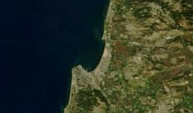
Based on
| Deskripsyon | Satellite image of Israel in January 2003. |
| Petsa | |
| Gigikanan | Cropped from original: http://visibleearth.nasa.gov/view_rec.php?id=4969 |
| Tagsulat | Jacques Descloitres, MODIS Rapid Response Team, NASA/GSFC |
Pagtugot
| This file is in the public domain in the United States because it was solely created by NASA. NASA copyright policy states that "NASA material is not protected by copyright unless noted". (See Template:PD-USGov, NASA copyright policy page or JPL Image Use Policy.) | ||
 |
Warnings:
|
Kaagi sa payl
I-klik ang petsa/oras aron makit-an ang hulagway sa payl niadtong panahona.
| Petsa/Takna | Thumbnail | Mga dimensyon | Tiggamit | Komento | |
|---|---|---|---|---|---|
| kasamtangan | 09:39, 3 Hunyo 2008 | | 273 × 160 (7 KB) | Ori~ | {{Information |Description= |Source= |Date= |Author= |Permission= |other_versions= }} |
| 09:37, 3 Hunyo 2008 |  | 305 × 311 (15 KB) | Ori~ | Based on {{Information |Description = Satellite image of Israel in January 2003. |Source = Cropped from original: http://visibleearth.nasa.gov/view_rec.php?id=4969 |Date = 2003-02-17 |Author = Jacques Descloitres, MODIS Rapid Response Te |
Mga paggamit sa payl
Ang mosunod nga mga panid misumpay niining payl:
Global nga paggamit sa payl
Kining ubang wiki naggamit ning maong payl:
- Paggamit sa ar.wikipedia.org
- Paggamit sa cs.wikipedia.org
- Paggamit sa eu.wikipedia.org
- Paggamit sa he.wikipedia.org
- Paggamit sa ru.wikipedia.org
- Paggamit sa uk.wikipedia.org
- Paggamit sa www.wikidata.org