
Payl:Satsunan-Islands-Kagoshima-Japan.png

Gidak-on ning maong paunang tan-aw: 391 x 599 ka mga piksel. Uban pang mga resoluyon: 157 x 240 ka mga piksel | 313 x 480 ka mga piksel | 501 x 768 ka mga piksel | 668 x 1,024 ka mga piksel | 1,622 x 2,484 ka mga piksel.
Tibuok resolusyon (1,622 × 2,484 pixels, size sa payl: 1.24 MB, MIME type: image/png)
Mubong sugid:
| Deskripsyon |
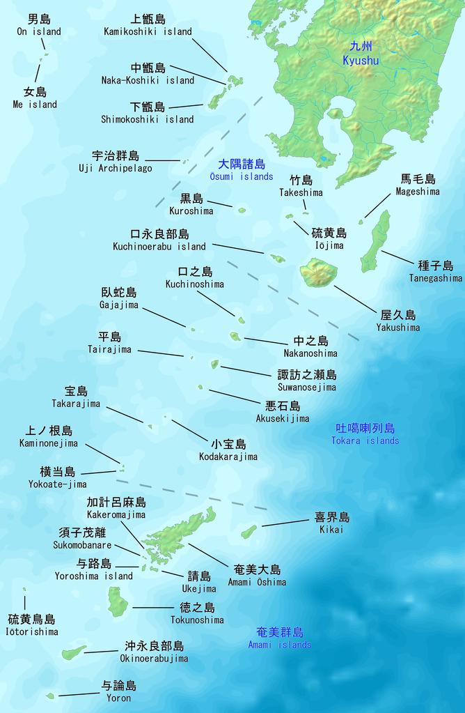
English: Map of the Satsunan Islands of Kagoshima, Japan. Made with DEMIS World Map Server.
日本語: 薩南諸島の地図。 鹿児島、日本。 |
||||
| Petsa | |||||
| Gigikanan | https://www.demis.nl/products/web-map-server/examples | ||||
| Tagsulat |
DEMIS World Map Server, Artanisen
|
Pagtugot
| This file is made available under the Creative Commons CC0 1.0 Universal Public Domain Dedication. | |
| The person who associated a work with this deed has dedicated the work to the public domain by waiving all of their rights to the work worldwide under copyright law, including all related and neighboring rights, to the extent allowed by law. You can copy, modify, distribute and perform the work, even for commercial purposes, all without asking permission.
|
Kaagi sa payl
I-klik ang petsa/oras aron makit-an ang hulagway sa payl niadtong panahona.
| Petsa/Takna | Thumbnail | Mga dimensyon | Tiggamit | Komento | |
|---|---|---|---|---|---|
| kasamtangan | 20:04, 22 Oktubre 2019 | | 1,622 × 2,484 (1.24 MB) | Artanisen | Added Sukomobanare island (須子茂離島). |
| 05:09, 21 Oktubre 2019 |  | 1,622 × 2,484 (1.22 MB) | Artanisen | Added info about the Tokara islands, Amami islands and Osumi islands. | |
| 20:23, 20 Oktubre 2019 |  | 1,622 × 2,484 (1.15 MB) | Artanisen | User created page with UploadWizard |
Mga paggamit sa payl
Ang mosunod nga 2 panid misumpay niining payl:
Global nga paggamit sa payl
Kining ubang wiki naggamit ning maong payl:
- Paggamit sa ar.wikipedia.org
- Paggamit sa az.wikipedia.org
- Paggamit sa bg.wikipedia.org
- Paggamit sa bn.wikipedia.org
- Paggamit sa ca.wikipedia.org
- Paggamit sa cs.wikipedia.org
- Paggamit sa de.wikipedia.org
- Paggamit sa en.wikipedia.org
- Paggamit sa es.wikipedia.org
- Paggamit sa fa.wikipedia.org
- Paggamit sa fr.wikipedia.org
- Paggamit sa gl.wikipedia.org
- Paggamit sa id.wikipedia.org
- Paggamit sa it.wikipedia.org
- Paggamit sa ja.wikipedia.org
View more global usage of this file.