
Payl:South Africa KwaZulu-Natal location map.svg

Size of this PNG preview of this SVG file: 526 x 600 ka mga piksel. Uban pang mga resoluyon: 210 x 240 ka mga piksel | 421 x 480 ka mga piksel | 674 x 768 ka mga piksel | 898 x 1,024 ka mga piksel | 1,796 x 2,048 ka mga piksel | 1,000 x 1,140 ka mga piksel.
Tibuok resolusyon (SVG nga payl, nominally 1,000 × 1,140 pixels, size sa payl: 244 KB)
Mubong sugid:
| Deskripsyon |
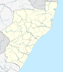
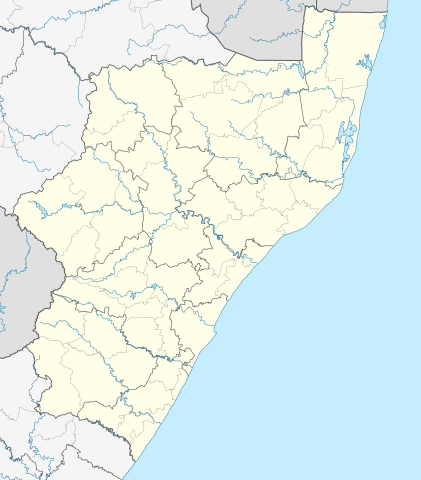
English: Location map of KwaZulu-Natal
Equirectangular projection, N/S stretching 114%. Geographic limits of the map:
|
| Petsa | |
| Gigikanan |
|
| Tagsulat | Htonl |
| Pagtugot (Paggamit pag-usab niini nga file) |
I, the copyright holder of this work, hereby publish it under the following license: This file is licensed under the Creative Commons Attribution-Share Alike 3.0 Unported license.
|
| Other versions | File:South Africa KwaZulu-Natal relief location map.svg, File:Blank map of KwaZulu-Natal (2011).svg |
.svg)
Kaagi sa payl
I-klik ang petsa/oras aron makit-an ang hulagway sa payl niadtong panahona.
| Petsa/Takna | Thumbnail | Mga dimensyon | Tiggamit | Komento | |
|---|---|---|---|---|---|
| kasamtangan | 11:21, 5 Enero 2013 | | 1,000 × 1,140 (244 KB) | Htonl | == {{int:filedesc}} == {{Information |Description ={{en|Location map of en:KwaZulu-Natal Equirectangular projection, N/S stretching 118%. Geographic limits of the map: * N: 26.75° S * S: 31.25° S * W: 28.75° E * E: 33.25° E}} |Source ... |
Mga paggamit sa payl
Ang mosunod nga 31 panid misumpay niining payl:
- AMalongwane
- AMantshontsho
- AMaxolobana
- Alcock Spruit
- Amanzimnyama
- Amawelawela
- Baas Ben's Stream
- Beestekraalrivier
- Brakspruit (suba nga anhianhi sa Habagatang Aprika, Province of KwaZulu-Natal)
- Dongalwenkonyane
- Doringspruit
- Isibindi
- Joubertsvlei se Loop
- Kaalspruit (suba sa Habagatang Aprika, Province of KwaZulu-Natal)
- Kalbasrivier
- Katspruit (suba sa Habagatang Aprika, Province of KwaZulu-Natal)
- Manzana (suba sa Habagatang Aprika, Province of KwaZulu-Natal, lat -28,80, long 29,13)
- Mlambonja
- Mlambonja (suba sa Habagatang Aprika, lat -28,77, long 29,30)
- Mlambonja (suba sa Habagatang Aprika, lat -29,74, long 29,30)
- Mnweni (suba sa Habagatang Aprika)
- Mooi River (suba sa Habagatang Aprika)
- Mpandweni
- Msunduzi
- Mzimayi
- Nhlambamasoka (suba sa Habagatang Aprika, lat -28,77, long 29,25)
- Nxwaye
- Old Woman Stream (KwaZulu-Natal)
- Sandlwana (suba sa Habagatang Aprika)
- Woodstock Dam (tubiganan)
- Plantilya:Location map South Africa KwaZulu-Natal
Global nga paggamit sa payl
Kining ubang wiki naggamit ning maong payl:
- Paggamit sa af.wikipedia.org
- Durban
- Pietermaritzburg
- KwaMbonambi
- Amanzimtoti
- Margate, KwaZulu-Natal
- Weenen
- Mtunzini
- New Hanover, KwaZulu-Natal
- Ladysmith
- Kokstad
- Balgowan, KwaZulu-Natal
- Nottingham Road
- Nieu-Guelderland
- Vryheid, KwaZulu-Natal
- Utrecht, KwaZulu-Natal
- Hilton
- Ixopo
- Dannhauser
- Nkandla
- Newcastle, KwaZulu-Natal
- Ncandu-waterval
- Colenso
- Bergville
- Verulam
- Empangeni
- Greytown
- Hattingspruit
- Melmoth
- Mooirivier (KwaZulu-Natal)
- Scottburgh
- Port Shepstone
- KwaDukuza
- Louwsburg
- Tongaat
- Howick
- Glencoe, KwaZulu-Natal
- Richardsbaai
- Mahlabatini
- Estcourt
- Pinetown
- Sezela
- Nongoma
- Ulundi
- Eshowe
- Hluhluwe
- Charlestown, KwaZulu-Natal
- Harding
- Mkuze
- Paulpietersburg
- Kingsburgh
View more global usage of this file.