
Payl:Stewart Street, South Norfolk.jpg

Gidak-on ning maong paunang tan-aw: 800 x 532 ka mga piksel. Uban pang mga resoluyon: 320 x 213 ka mga piksel | 640 x 426 ka mga piksel | 1,024 x 681 ka mga piksel | 1,280 x 851 ka mga piksel | 2,560 x 1,702 ka mga piksel | 6,016 x 4,000 ka mga piksel.
Tibuok resolusyon (6,016 × 4,000 pixels, size sa payl: 6.99 MB, MIME type: image/jpeg)
|
This is an image of a place or building that is listed on the National Register of Historic Places in the United States of America. Its reference number is 88003133. |
| Camera location | | View this and other nearby images on: OpenStreetMap |
|---|
| Deskripsyon |
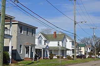
English: Houses on Stewart Street, seen looking north from Ohio Street, in Chesapeake, Virginia, United States. This block is part of the South Norfolk Historic District, a historic district that is listed on the National Register of Historic Places. |
||
| Petsa | Taken on 24 Pebrero 2018 | ||
| Gigikanan | Kaugalingong trabaho | ||
| Tagsulat | Nyttend | ||
| Pagtugot (Paggamit pag-usab niini nga file) |
|
||
| Other versions | None |
Kaagi sa payl
I-klik ang petsa/oras aron makit-an ang hulagway sa payl niadtong panahona.
| Petsa/Takna | Thumbnail | Mga dimensyon | Tiggamit | Komento | |
|---|---|---|---|---|---|
| kasamtangan | 15:36, 10 Marso 2018 | | 6,016 × 4,000 (6.99 MB) | Nyttend |
Mga paggamit sa payl
Ang mosunod nga mga panid misumpay niining payl:
Global nga paggamit sa payl
Kining ubang wiki naggamit ning maong payl:
- Paggamit sa en.wikipedia.org
- Paggamit sa en.wikivoyage.org
- Paggamit sa www.wikidata.org