
Payl:Valencia-loc.svg

Size of this PNG preview of this SVG file: 547 x 599 ka mga piksel. Uban pang mga resoluyon: 219 x 240 ka mga piksel | 438 x 480 ka mga piksel | 701 x 768 ka mga piksel | 934 x 1,024 ka mga piksel | 1,869 x 2,048 ka mga piksel | 2,003 x 2,195 ka mga piksel.
Tibuok resolusyon (SVG nga payl, nominally 2,003 × 2,195 pixels, size sa payl: 443 KB)
Mubong sugid:
| Deskripsyon |
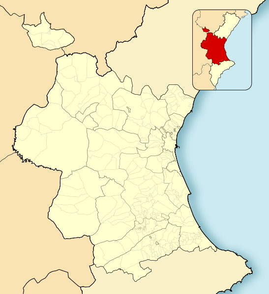
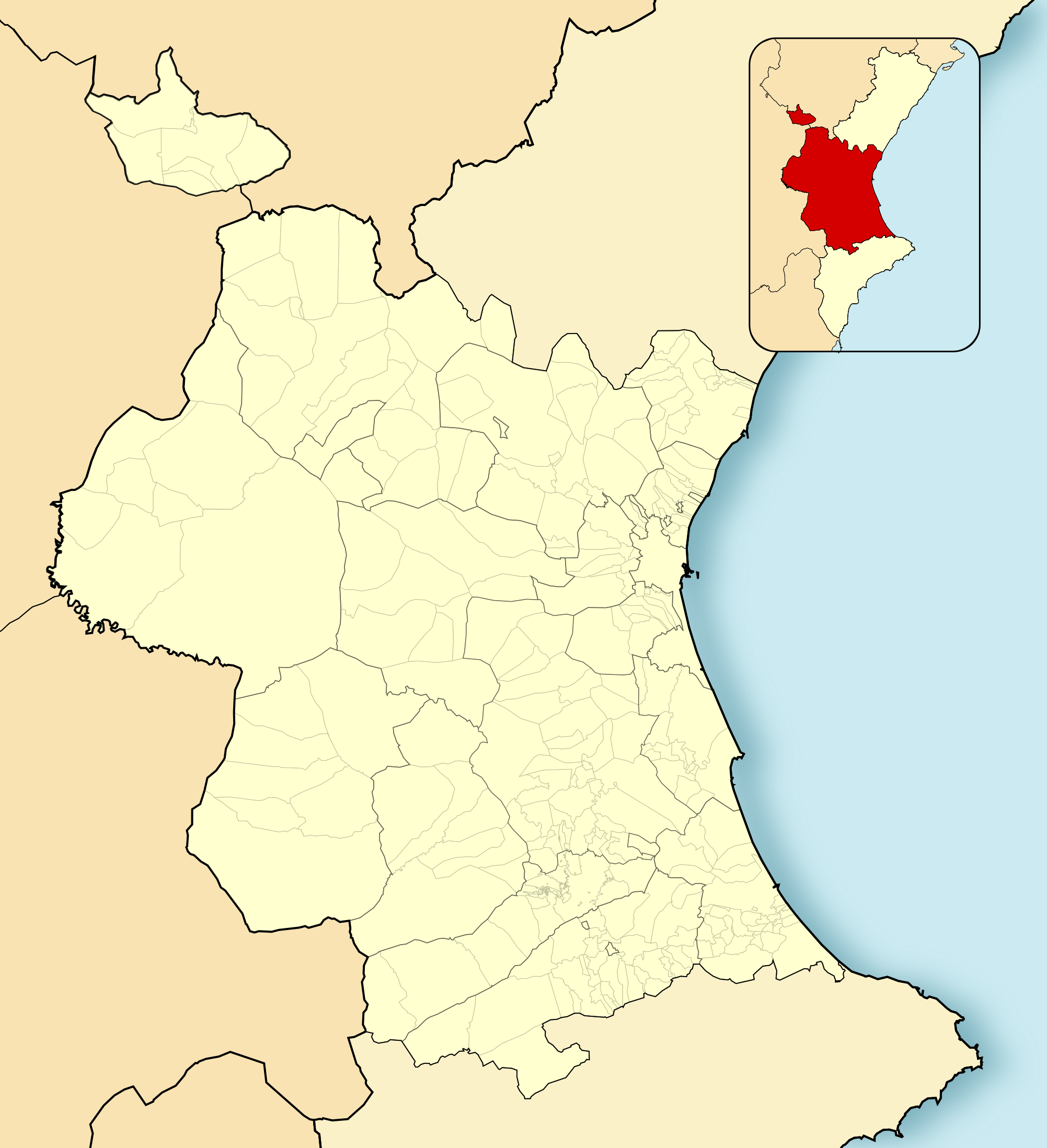
English: Location map of Province of Valencia
Equirectangular projection, N/S stretching 130 %. Geographic limits of the map:
Español: Mapa de localización de la Provincia de Valencia
Proyección equirrectangular, N/S estirada 130 %. Límites geográficos del mapa:
|
|
| Petsa | ||
| Gigikanan | Own work based on: EspañaLoc.svg | |
| Tagsulat | Miguillen | |
| SVG genesis | This W3C-invalid locator map was created with Adobe Illustrator, and with Inkscape.
|
Pagtugot
Miguillen, the copyright holder of this work, hereby publishes it under the following license:
This file is licensed under the Creative Commons Attribution-Share Alike 3.0 Unported license.
Attribution: Miguillen
- Libre ka:
- sa pagsabwag – sa pagkopya, pag-apod-apod ug pagsabwag sa hinimo
- sa pag-remix – sa pag-adap sa binuhat
- Ubos sa mosunod nga mga kondisyon:
- atribusyon – Kinahanglan nimo nga hatagan ang angay nga kredito, maghatag usa ka link sa lisensya, ug ipakita kung adunay mga pagbag-o. Mahimo nimo kini buhaton sa bisan unsang makatarunganon nga paagi, apan dili sa bisan unsang paagi nga nagsugyot nga gi-endorso ka sa licensor o ang imong paggamit.
- share parehas – Kung imong gi-remix, gibag-o, o gibase sa materyal, kinahanglan nimo nga iapod-apod ang imong mga kontribusyon sa ilawom sa parehas o katugma nga lisensya sama sa orihinal.
Kaagi sa payl
I-klik ang petsa/oras aron makit-an ang hulagway sa payl niadtong panahona.
| Petsa/Takna | Thumbnail | Mga dimensyon | Tiggamit | Komento | |
|---|---|---|---|---|---|
| kasamtangan | 15:32, 8 Disyembre 2010 | | 2,003 × 2,195 (443 KB) | Miguillen | colores |
| 10:47, 24 Nobiyembre 2010 |  | 2,003 × 2,195 (443 KB) | Miguillen | límites | |
| 10:36, 24 Nobiyembre 2010 |  | 2,003 × 2,195 (531 KB) | Miguillen | Diferencio terriotorio CCAA y añado mapa de ubicación en ella | |
| 16:00, 16 Nobiyembre 2010 |  | 2,003 × 2,195 (407 KB) | Miguillen | trazos | |
| 15:55, 16 Nobiyembre 2010 |  | 2,003 × 2,195 (382 KB) | Miguillen | == {{int:filedesc}} == {{Information |Description={{en|Location map of Province of Valencia}} Equirectangular projection, N/S stretching 130 %. Geographic limits of the map: * N: ° N * S: ° N * W: ° O * E: ° E {{es|Ma |
Mga paggamit sa payl
Ang mosunod nga mga panid misumpay niining payl:
Global nga paggamit sa payl
Kining ubang wiki naggamit ning maong payl:
- Paggamit sa ar.wikipedia.org
- Paggamit sa ast.wikipedia.org
- Paggamit sa ba.wikipedia.org
- Paggamit sa bn.wikipedia.org
- Paggamit sa ca.wikipedia.org
- Paggamit sa en.wikipedia.org
- Carcaixent
- Cofrentes
- Ontinyent
- Torrent, Valencia
- Sinarcas
- Cullera
- Mislata
- Daimús
- Tavernes de la Valldigna
- Xirivella
- Sagunto
- Benigànim
- Mogente/Moixent
- Alcàsser
- Alfauir
- Barx
- Benifairó de la Valldigna
- Burjassot
- Carlet
- Castellonet de la Conquesta
- Chera, Valencia
- Dos Aguas
- Foios
- La Font de la Figuera
- Llombai
- Moncada, Valencia
- Paterna
- Puçol
- Quart de Poblet
- Salem, Valencia
- Simat de la Valldigna
- Xeraco
- Xeresa
- Algímia d'Alfara
- Primera División de Baloncesto
- Valencia History Museum
- Module:Location map/data/Spain Province of Valencia/doc
- Module:Location map/data/Spain Province of Valencia
- Cueva de Bolomor
- User:Ceahjlazco1882/Infobox settlement Sandbox
View more global usage of this file.