
Payl:YaldingBeult0514.JPG
Gidak-on ning maong paunang tan-aw: 800 x 600 ka mga piksel. Uban pang mga resoluyon: 320 x 240 ka mga piksel | 640 x 480 ka mga piksel | 1,024 x 768 ka mga piksel | 1,280 x 960 ka mga piksel | 2,016 x 1,512 ka mga piksel.
Tibuok resolusyon (2,016 × 1,512 pixels, size sa payl: 749 KB, MIME type: image/jpeg)
Mubong sugid:
| Deskripsyon |
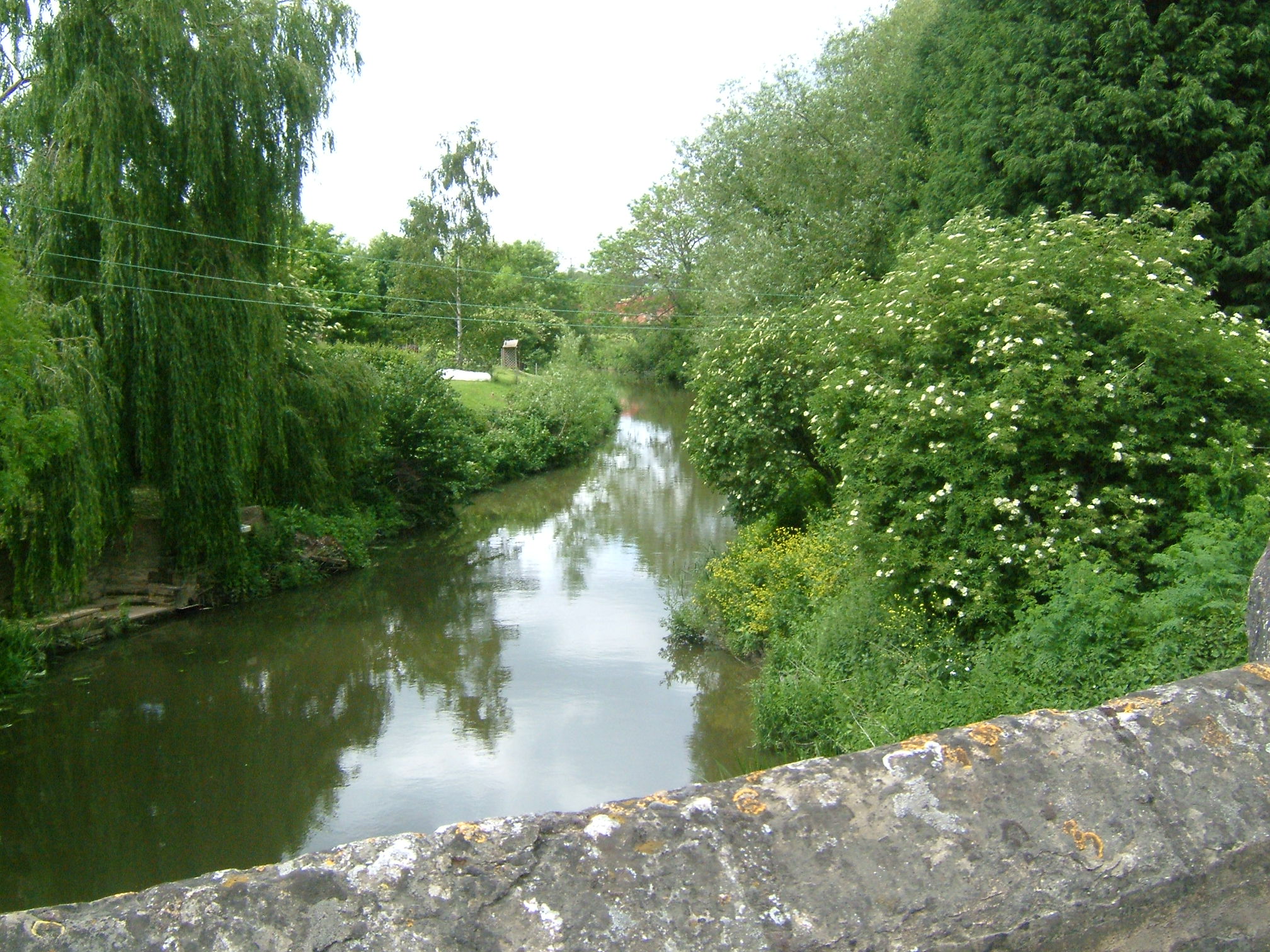
English: View from Yalding Bridge or Town Bridge, on the River Beult at Yalding, Kent. Riverside homes on the River Beult at Yalding behind the post office, just before it joins the Medway. At Yalding there is an automatic sluice where the Medway drops from +11.2m to +7.41m above mean sea level (which it is here). The navigation bears left through Hampstead Lane Canal and Hampstead Lock; the main stream drops over the weir and sluice and is joined by the River Teise (Lesser Teise), and both pass under Twyford Bridge. The river then flows in a loop towards Yalding, where it is joined by the River Beult which has been joined by the River Teise (the other bit!) and passes under Town Bridge. Town bridge is 10 miles from Allington. Town bridge is the longest mediaeval bridge in Kent. |
| Petsa | |
| Gigikanan | Kaugalingong trabaho |
| Tagsulat | Clem Rutter, Rochester, Kent. |
Pagtugot
I, the copyright holder of this work, hereby publish it under the following licenses:

|
Gitugot ang pagkopya, pag-apud-apod o/ug pag-usab ning maong dokumento ubos sa mga termino sa GNU Free Documentation License, Version 1.2 o mas bag-ong bersiyon nga gimantala sa Free Software Foundation; nga walay Invariant Sections, walay Front-Cover Texts, ug walay Back-Cover Texts. Ang kopya sa lisensiya gilakip sa bahin nga giulohang GNU Free Documentation License. |
| This file is licensed under the Creative Commons Attribution-Share Alike 3.0 Unported license. | ||
| ||
| This licensing tag was added to this file as part of the GFDL licensing update. |
This file is licensed under the Creative Commons Attribution 2.5 Generic license.
- Libre ka:
- sa pagsabwag – sa pagkopya, pag-apod-apod ug pagsabwag sa hinimo
- sa pag-remix – sa pag-adap sa binuhat
- Ubos sa mosunod nga mga kondisyon:
- atribusyon – Kinahanglan nimo nga hatagan ang angay nga kredito, maghatag usa ka link sa lisensya, ug ipakita kung adunay mga pagbag-o. Mahimo nimo kini buhaton sa bisan unsang makatarunganon nga paagi, apan dili sa bisan unsang paagi nga nagsugyot nga gi-endorso ka sa licensor o ang imong paggamit.
You may select the license of your choice.
Kaagi sa payl
I-klik ang petsa/oras aron makit-an ang hulagway sa payl niadtong panahona.
| Petsa/Takna | Thumbnail | Mga dimensyon | Tiggamit | Komento | |
|---|---|---|---|---|---|
| kasamtangan | 13:31, 3 Hunyo 2007 | | 2,016 × 1,512 (749 KB) | ClemRutter | == Summary == {{Information |Description= Riverside dwellings on the River Beult at Yalding behind the post office, just before it joins the Medway. At Yalding there is an automatic sluice where the river drops from +11.2m to +7.41m above mean sea level ( |
Mga paggamit sa payl
Ang mosunod nga mga panid misumpay niining payl:
Global nga paggamit sa payl
Kining ubang wiki naggamit ning maong payl:
- Paggamit sa da.wikipedia.org
- Paggamit sa en.wikipedia.org
- Paggamit sa ru.wikipedia.org
- Paggamit sa sv.wikipedia.org
- Paggamit sa www.wikidata.org