
Payl:Zealandia-Continent map en.svg

Size of this PNG preview of this SVG file: 547 x 599 ka mga piksel. Uban pang mga resoluyon: 219 x 240 ka mga piksel | 438 x 480 ka mga piksel | 701 x 768 ka mga piksel | 935 x 1,024 ka mga piksel | 1,870 x 2,048 ka mga piksel | 789 x 864 ka mga piksel.
Tibuok resolusyon (SVG nga payl, nominally 789 × 864 pixels, size sa payl: 327 KB)

Mubong sugid:
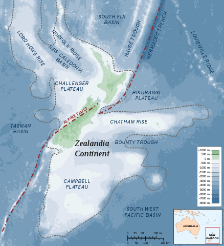
| Deskripsyon | Map of the Zealandia (continent) |
| Petsa | |
| Gigikanan |
Own work Bathymetry: ETOPO2v2 2min - edited with Inkscape, Land Information New Zealand, Te Ara The Encyclopedia of New Zealand |
| Tagsulat | Alexrk |
| Pagtugot (Paggamit pag-usab niini nga file) |
Creative Commons : share alike - attribution required |
| Other versions |
 (topographic) (topographic) |


|
This SVG file contains embedded text that can be translated into your language, using any capable SVG editor, text editor or the SVG Translate tool. For more information see: About translating SVG files. |
Pagtugot
I, the copyright holder of this work, hereby publish it under the following license:
This file is licensed under the Creative Commons Attribution-Share Alike 3.0 Unported license.
- Libre ka:
- sa pagsabwag – sa pagkopya, pag-apod-apod ug pagsabwag sa hinimo
- sa pag-remix – sa pag-adap sa binuhat
- Ubos sa mosunod nga mga kondisyon:
- atribusyon – Kinahanglan nimo nga hatagan ang angay nga kredito, maghatag usa ka link sa lisensya, ug ipakita kung adunay mga pagbag-o. Mahimo nimo kini buhaton sa bisan unsang makatarunganon nga paagi, apan dili sa bisan unsang paagi nga nagsugyot nga gi-endorso ka sa licensor o ang imong paggamit.
- share parehas – Kung imong gi-remix, gibag-o, o gibase sa materyal, kinahanglan nimo nga iapod-apod ang imong mga kontribusyon sa ilawom sa parehas o katugma nga lisensya sama sa orihinal.
Kaagi sa payl
I-klik ang petsa/oras aron makit-an ang hulagway sa payl niadtong panahona.
| Petsa/Takna | Thumbnail | Mga dimensyon | Tiggamit | Komento | |
|---|---|---|---|---|---|
| kasamtangan | 22:37, 19 Hulyo 2010 | | 789 × 864 (327 KB) | Beao | Removed border. |
| 11:59, 1 Hunyo 2009 |  | 797 × 871 (375 KB) | Alexrk | Removed Grid | |
| 14:19, 20 Enero 2008 |  | 797 × 871 (380 KB) | Alexrk | ||
| 14:10, 20 Enero 2008 |  | 797 × 871 (380 KB) | Alexrk | ||
| 16:44, 19 Enero 2008 |  | 797 × 871 (380 KB) | Alexrk | ||
| 15:55, 19 Enero 2008 |  | 797 × 871 (380 KB) | Alexrk | ||
| 15:52, 19 Enero 2008 |  | 1,000 × 1,000 (380 KB) | Alexrk | == Summary == {{Information |Description=Map of the Zealandia Continent |Source=Own work<br/>Bathymetry: ETOPO2v2 2min - vectorized with Inkscape, Land Information New Zealand, Te Ara The Encyclopedia of New Zealand |Date=Jan 2008 |Date=J |
Mga paggamit sa payl
Ang mosunod nga mga panid misumpay niining payl:
Global nga paggamit sa payl
Kining ubang wiki naggamit ning maong payl:
- Paggamit sa af.wikipedia.org
- Paggamit sa ang.wikipedia.org
- Paggamit sa ast.wikipedia.org
- Paggamit sa cs.wikipedia.org
- Paggamit sa de.wikipedia.org
- Paggamit sa en.wikipedia.org
- Geography of New Zealand
- Hikurangi Trench
- Alpine Fault
- Portal:New Zealand
- Metanephrops challengeri
- User:Epipelagic/sandbox/sources
- Volcanism of New Zealand
- Hikurangi Plateau
- Puysegur Trench
- Talk:Zealandia
- Fishing industry in New Zealand
- Geology of New Zealand
- List of submarine topographical features
- Wikipedia:Reference desk/Archives/Science/2015 May 26
- Paggamit sa eo.wikipedia.org
- Paggamit sa es.wikipedia.org
- Paggamit sa hi.wikipedia.org
- Paggamit sa hu.wikipedia.org
- Paggamit sa hy.wikipedia.org
- Paggamit sa id.wikipedia.org
- Paggamit sa incubator.wikimedia.org
- Paggamit sa it.wikipedia.org
- Paggamit sa ja.wikipedia.org
- Paggamit sa ka.wikipedia.org
- Paggamit sa nl.wikipedia.org
View more global usage of this file.